Expert's Opinion
Podcast
Effective Management of Spatial Data Transactions

Contents
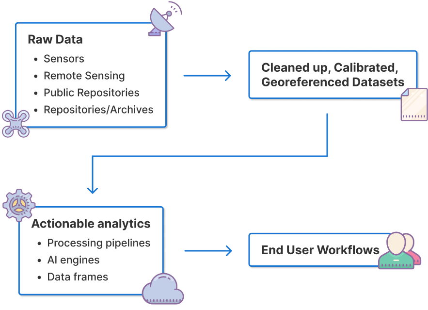
The Anatomy of a Spatial Data Transaction
In the latest edition of The Ellipsis Drive Podcast, our CEO Rosalie was joined by Andy Bell SVP - Global Data Product Management at Precisely. Having worked in the geospatial world for over 30 years, Andy is in a perfect position to comment on the changing nature of the below outlined spatial data transactions that make up our industry. He imparts some valuable advice to business leaders that are keen on integrating spatial data operations to their business operations. This blog will recap the core concepts of that talk.
Let’s start by zooming in on some of the big changes that have occurred in the spatial data ecosystem in recent years.
Key characteristics of spatial data transactions
There are 3 key trends that characterize the spatial data transactions carried out in today’s day and age –
Scale and Complexity
“If I go back 10-15 years ago, spatial transactions were fairly straightforward. For example, companies wanted some simple boundary data, postcodes or demographics. From that point, the scale and complexity of these transactions has grown. We’ve come up with advanced data collection methods, increased cross industry integration and developed more sophisticated analytics and GIS tools.” said Andy.
Diversity of Buyers
“We’re moving away from GIS specialists to much more general users – such as data scientists and deployment within other operational processes across the business. That’s an interesting progression. The access to geospatial data is expanding enormously. And of course that’s coupled with the scale and complexity that I mentioned earlier. Businesses are looking for detailed property information and data that is interconnected.” said Andy.
The increased availability of geospatial datasets, open-source geospatial platforms and cloud based solutions has democratized access, enabling various industries and their stakeholders to leverage location-based insights. The shift reflects the growing need for interconnected, detailed property and geo information, as businesses seek to optimize operations and make data-driven decisions.
As the global leader in data integrity, Precisely works with over 12,000 customers globally to ensure their data is accurate, consistent, and contextual - and an essential element of this is reliable data enrichment and address management. By leveraging curated and trustworthy third-party datasets businesses can avoid time-consuming, and often complicated, data preparation and more easily share geospatial insights with users across the business.
Diversity of Data Delivery
“Not long ago, you’d burn data onto a CD and post it. Now everybody wants everything. They want non-premise delivery via digital download, SDK, and API access. Also, with the rise of cloud services they want that data deployed directly into their cloud environment, such as Snowflake or Databricks.” said Andy.
Everybody wanting everything is not a bad thing. But it has the potential for disaster if the right infrastructure isn’t in place. Especially when combined with industry trends such as the rapid wide-spread adoption of AI. AI models thrive on large volumes of accurate, real-time geospatial data. A stable infrastructure becomes critical to ensure seamless access, processing, and delivery of high-quality data. Without a reliable foundation—capable of supporting modern delivery methods like APIs, SDKs, and cloud integration—the potential for AI-driven innovations could be stifled, leading to inefficiencies and data inconsistencies that could disrupt operational processes.
Infrastructural Challenges Arising due to Complex Spatial Data Transaction
In the present day there are a large number of highly spatial data transactions, delivered to a diversified set of buyers through countless different mediums. It’s safe to say that the spatial data ecosystem has evolved. But has the infrastructure supporting it evolved along with it?
“Today’s spatial data infrastructure is not intuitive or flexible enough to accommodate these new market dynamics. Particularly when you see the volume of data and the use of complex ML algorithms. Although users have diversified, geospatial data is still often seen as specialist. Many of the general data management solutions haven’t fully grasped the complexity of geospatial data. They still think of it as a point on the map. But we know that this data—whether it be satellite imagery in raster format or boundaries— becomes quite complex and heavy to manage. This is a challenge for businesses because there is increased awareness and understanding that AI and ML models are essentially useless without accurate, consistent, and contextual data powering them in order to deliver trustworthy outcomes.”
Below are some of the challenges arising due to a sub-par spatial data infrastructure (SDI):
Manual Integration → Spatial data inputs entering analytical workflows look different each time. This creates an integration challenge that requires a lot of manual intervention.
Privacy and Confidentiality → Geospatial data contains sensitive information. Navigating privacy regulations and implementing data protection measures is quite a challenge.
Version & Access Control → Providing selective access and managing different versions of spatial data products to provide up-to-date pieces of information to clients is a major challenge.
Effective Management of Spatial Data Transactions
“Effective management of spatial data begins with effectively understanding spatial data and the use cases that they intend to serve. The complexity of spatial data needs to be acknowledged.” said Andy.
Once this foundation has been established, business leaders can make smarter decisions for creating an intuitive and flexible environment for the seamless transaction of spatial data. Below are some of the key traits of a stable spatial data infrastructure:
Accessibility - The baseline infrastructure created for spatial data must have an intuitive user interface. Users of all technical levels should be able to login, create and transact with minimal effort.
Interoperability - It must make transacting via existing protocols easier rather than coming up with new protocols itself. A sender should be able to send without needing any new setup, or without worrying about which protocol to choose. Similarly, the receiver should also have the freedom to choose the mode of data transfer.
Scalability - The Spatial Data Infrastructure should support various data formats, incorporate the latest geospatial technologies and translate across different business use cases without much intervention.
Conclusion
The effective management of spatial data transactions hinges on acknowledging the increasing complexity of spatial data and the growing diversity of its users. As the scale of data collection, integration, and delivery continues to expand, organizations must prioritize building flexible, scalable, and user-friendly infrastructures that ensure seamless access to and transaction of geospatial data. By addressing challenges like manual integration, privacy, and version control, businesses can create a stable spatial data environment that supports evolving market demands and allows for the full potential of spatial data to be realized.
We’d like to thank Andy for taking the time to share his insights on this subject. We are confident that when these realizations are acted upon by other thought leaders, they will create synergy and growth throughout the spatial data ecosystem. Be sure to watch the full podcast here.
Liked what you read?

Subscribe to our monthly newsletter to receive the latest blogs, news and updates.
Take the Ellipsis Drive tour
in less than 2 minutes'
- A step-by-step guide on how to activate your geospatial data
- Become familiar with our user-friendly interface & design
- View your data integration options
