Use Case
Air Pollution Management ft. TNO
Contents
Introduction
The World Bank estimates that air pollution costs the global economy USD 5 trillion each year. As industries, agricultural and urban areas continue to grow, the environmental impacts of pollutants—especially those tied to climate change—become more pronounced, affecting everything from agricultural yields to infrastructure resilience. Monitoring and managing these pollutants has never been more critical.
To delve deeper into this matter, the latest episode of The Ellipsis Drive Podcast featured Martijn Schaap, Principle Scientist of Air Quality at TNO. TNO is a one of a kind research organization with a mission to bridge fundamental sciences taught at Universities with their societal applications. The organization’s vast experience with monitoring air pollution was the focal point of the conversation between Martijn and our CEO, Rosalie van der Maas.
This article covers the key topics of that conversation and sheds light on TNO’s initiatives to combat pollution (particularly rising nitrogen levels) in Europe. Let’s go!
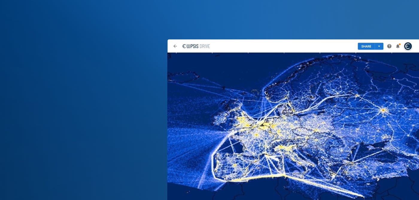
TNO’s Nitrogen Mapping – From Emission to Deposition
In recent years, there has been a concerning surge in nitrogen levels in the atmosphere, primarily due to increased industrial activity, agriculture, and transportation. This rise in nitrogen compounds, especially nitrogen oxides (NOx) and ammonia (NH₃), has become a significant environmental challenge. These pollutants contribute to the formation of fine particulate matter, ground-level ozone, and acid rain, which pose severe risks to public health, ecosystems, and climate.
“The Netherlands is one of the hotspots for Nitrogen emissions. At TNO, we monitor the entire nitrogen chain, right from emission to deposition. This covers how the pollutant is transported, transformed and deposited from the atmosphere into the surface. So, for example, nitrogen oxides get mixed into the atmosphere during agricultural practices or heavy traffic. Then they’re transported via air currents. Chemical transformation occurs in the atmosphere, and at some point, it rains down or gets directly mixed into the Earth’s surface.” said Martijn.
TNO has designed a modeling system called LOTOS-EUROS that identifies the causal relationship between emissions and depositions of nitrogen oxides. This informs business leaders and policymakers about the current state of the atmosphere and enables them to make sound decisions.
The LOTOS-EUROS (Long-Term Ozone and Short-Term Ozone - European Operational Smog) modeling system is a powerful open-source tool used for simulating air quality and atmospheric composition across Europe. It plays a critical role in understanding the dynamics of air pollution, especially nitrogen compounds, by combining both chemical transport and meteorological modeling.
“The deposition map is a creation derived out of 3 unique data sets. The emissions data received from European Emission maps, the weather data report from meteorology departments to understand atmospheric conditions, and thirdly the land use and vegetation map to understand the reaction of the pollutants with the surface.” said Martijn.
LOTOS-EUROS is widely applied in several key areas, including:
- Air Quality Monitoring and Forecasting: The system is employed to predict air quality levels, particularly the concentrations of pollutants like nitrogen oxides (NOx), ammonia (NH₃), and particulate matter. These forecasts help governments and agencies take proactive measures to protect public health.
- Policy Development and Environmental Management: LOTOS-EUROS aids in formulating and evaluating environmental policies related to air pollution control. By providing reliable simulations, it supports decision-making for effective emissions reductions, such as those targeting agriculture and transportation sectors.
- Nitrogen Deposition Mapping: As part of its broader applications, LOTOS-EUROS is used to create detailed nitrogen deposition maps. These maps are essential for assessing the impact of nitrogen emissions on ecosystems, particularly in sensitive areas like nature reserves and agricultural zones.
- Cross-Border Pollution Impact Studies: The system’s ability to model long-range transport of pollutants makes it a valuable tool for understanding cross-border pollution effects. It helps to quantify the contribution of foreign sources to local air pollution, thus fostering international cooperation in air quality management.
“It has been a conscious decision to provide our map products as an open-source tool,” said Martijn. “In Germany, the nitrogen mapping is easily downloadable via a website for policy making, infrastructural projects etc. And because it is openly available, we’ve noticed people use it as input for all kinds of use cases that we were not even fully aware of. Like greenhouse gas research, water quality detection or ecosystem integrity. It’s great to see such innovation!”
Dissemination of Complex Spatial Data and Analytics Products
Of course, delivering such game-changing, next-generation analytics-heavy products like those generated by LOTOS-EUROS will come with some challenges. Next, we cover how products like these may face a range of data consumption and infrastructural hurdles primarily due to the complexity, volume, and nature of the data being processed and disseminated. Key issues include:
- Data Quality and Consistency: As mentioned earlier, the models rely on several different inputs such as emission maps, weather data, vegetation data etc. High-quality, consistent data is crucial for accurate modeling and analysis. However, ensuring the integrity of data over time, particularly when integrating diverse datasets from multiple sources, is a challenge.
- Data Processing and Computational Power: Modeling air quality and nitrogen deposition involves extensive computational simulations. The complex calculations needed to accurately represent atmospheric processes demand significant computational power, often requiring supercomputing resources or cloud-based infrastructure. Ensuring that these resources are available and scalable to handle peak demand is crucial for timely data delivery.
- Data Accessibility and Usability: With heavy analytical products, the data must be made accessible to a wide range of stakeholders, including policymakers, researchers, and the general public. Developing user-friendly interfaces, visualization tools, and application programming interfaces is essential for ensuring that the data is understandable, usable and actionable. This often requires additional layers of infrastructure such as web portals or cloud-based platforms, to manage and distribute data effectively.
“We’re a small team of specialists, mostly modelers,” said Martijn, “so to make everything openly available, according to the latest standards and in a timely manner, is always a challenge.”
“That’s the reason why we at Ellipsis Drive work to lower the threshold to make new datasets known and consumable for a broad audience. The original creators usually don’t have the time or experience to do so effectively, " said Rose. “Despite the challenges, it’s really good to hear that widespread use of this valuable open data is the intent of TNO. ”
Conclusion
TNO’s work with nitrogen mapping and air pollution modeling is not just groundbreaking—it's essential for tackling one of the most urgent environmental and public health challenges of our time. By providing open-source tools and fostering transparency, TNO is not only advancing scientific understanding but also empowering policymakers, businesses, and researchers to take meaningful action. Yet, despite these remarkable achievements, some natural challenges remain regarding data consistency, processing, and accessibility revealing that data management innovation will be part of the ongoing story to unleash products like these even further. The evolution of technologies such as LOTOS-EUROS will be crucial in shaping a future where cleaner air and healthier ecosystems are a reality. With TNO leading the way, the road to a more sustainable world is becoming a little clearer—one map at a time.
A big thank you to Martijn for giving us an inside look at TNO's vital work in addressing air pollution and nitrogen emissions. By sharing these insights, we’re reminded of how collaboration and transparency can drive meaningful change across industries. Together, we all play a role in creating a healthier, more sustainable future. Be sure to catch the full episode here.
Until next time!
Liked what you read?

Subscribe to our monthly newsletter to receive the latest blogs, news and updates.
Take the Ellipsis Drive tour
in less than 2 minutes'
- A step-by-step guide on how to activate your geospatial data
- Become familiar with our user-friendly interface & design
- View your data integration options

Related Articles

The Waterschapshuis: Drought Monitoring in The Netherlands
Despite the small size of the country, The Netherlands is the second largest exporter of agricultural products in the world. What’s their secret? What makes them tick? Well, it is a combination of ide
2 min read

Build Smart, Not Hard: How Element 84 Guides Clients with Spatial Data Infrastructure
For this episode of the Ellipsis Drive podcast, we sat down with Dan Pilone, CEO of Element 84, a geospatial engineering firm known for guiding organizations through some of their toughest technical
5 min read

EarthDefine: Protecting the Earth's Green Cover
Trees are the single most selfless beings on this planet. They have given so much to this world in so many ways. We literally owe them our lives by breathing in the precious oxygen that they produce.
3 min read