Use Case
EarthDefine: Protecting the Earth's Green Cover

Contents
Introduction
Trees are the single most selfless beings on this planet. They have given so much to this world in so many ways. We literally owe them our lives by breathing in the precious oxygen that they produce. They are also our best defense against global warming which is staring at us from the not-so-distant future (present?). For all that they have done for the Earth, they don't ask a lot in return. Just a little bit of care and a little bit of love.
EarthDefine: Mission, Vision and Product Offering
We introduce to you EarthDefine, a US based company, that is committed to preserving tree cover in the USA. EarthDefine’s flagship product is the US Tree Map, a high resolution tree canopy map that gives a detailed view of the tree cover in the entire country, allowing organizations to diligently use tree resources.
Using state of the art machine learning algorithms and advancements in computer vision, EarthDefine has managed to solve the classification challenges that the geospatial industry faced. An AI model is used to classify over 120 TB of high resolution imagery over 3.1 million square miles.
The best possible imagery available prior to EarthDefine was a 30-meter pixel resolution one by National Land Cover Database (NLCD). However, leveraging the above mentioned technology, EarthDefine has managed to create 1-meter pixel resolution images that can be used for advanced analysis which in turn means more use cases.
A 1-meter pixel resolution (900 times sharper imagery) allows you to identify intricate details such as gaps in forest, individual tree profiles and a lot more.
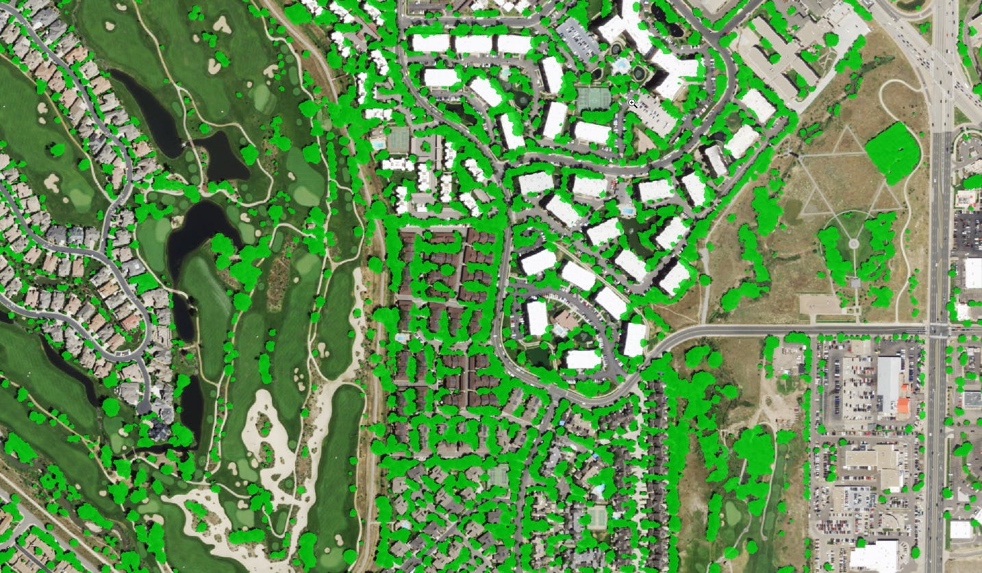
- US Tree Map over Aurora, Colorado
Benefits and Applications
EarthDefine’s database is updated annually as opposed to NLDC’s 5 year update cycle. Frequent updates allows for more accurate interpretation (96.6%) of ground realities and assessing the impact of deforestation, urbanization and natural disasters. This is done by doing a change analysis, which is a comparative study of the landscape over a prolonged period of time.
EarthDefine’s Tree Map finds applications in many different areas. Some of its key use cases are -
- Managing forest inventory
- Designing agroforestry plans
- Building defensive space to stop wildfires
Detecting trees with this level of quality and detail at that scale is a unique accomplishment!
Role of Ellipsis Drive
It does come with its set of challenges though. In creating the data, EarthDefine had approximately 19.000 geotiffs that needed to be merged into a single online map that can be serviced out to buyers as web service and be showcased to prospects by their sales force.
Enter Ellipsis Drive!
By uploading them to Ellipsis Drive, the huge heap of raw files were transformed into a live map and web service. Now the data can be shared, sold and used by countless people. Easy as that.
We have paved the way for EarthDefine’s product to be used and sold in the most seamless way possible.
Ellipsis Drive’s solution allows for selective access, which means EarthDefine can choose which clients of theirs can view which part of the dataset. A great feature to have when selling data and managing projects.
Conclusion
We feel this is the start of a long and successful relationship between two companies that truly believe in the power of geospatial data. When EarthDefine moves its other product offerings (Building Footprints, Parking Lots, Landcover) onto Ellipsis Drive the US tree cover map can be the first of a great series of successes.
EarthDefine is well on course to sharing its vision with the world, literally! Showcasing our Earth’s beautiful green cover is probably the best way to remind people of what we have and what we desperately need to cherish.
Liked what you read?

Subscribe to our monthly newsletter to receive the latest blogs, news and updates.
Take the Ellipsis Drive tour
in less than 2 minutes'
- A step-by-step guide on how to activate your geospatial data
- Become familiar with our user-friendly interface & design
- View your data integration options

Related Articles

The Waterschapshuis: Drought Monitoring in The Netherlands
Despite the small size of the country, The Netherlands is the second largest exporter of agricultural products in the world. What’s their secret? What makes them tick? Well, it is a combination of ide
2 min read

Build Smart, Not Hard: How Element 84 Guides Clients with Spatial Data Infrastructure
For this episode of the Ellipsis Drive podcast, we sat down with Dan Pilone, CEO of Element 84, a geospatial engineering firm known for guiding organizations through some of their toughest technical
5 min read
Connecting Earth Observation Datasets to End Users Ft. NomadIQ
“From established basic research and government land management to growing demand in carbon markets, hazard insurance, and even recreational apps, there's a rapidly developing market for satellite-ba
5 min read