GIS
Analysing and Sharing 3D (point cloud) data with a Simple Weblink!
Introduction
The geospatial industry is going through an incredible revolution as we speak. To be honest, it is not a big surprise, with new technology knocking at our doors every day. If you are a geospatial enthusiast like us then these prospects definitely intrigue you. We are definitely living through one of the most exciting times of the industry!
Past Scenario
Being extremely voluminous and heavy in nature (in the range of 100’s of GBs to 10s of TBs), geospatial data was shared via hard disks. Needless to say, collaboration was a painful experience. Project management was a nightmare. It was an experience marked by miscommunication, missed deadlines and constant back and forth. Repeat and happy customers were a rare sight and they were not to be blamed.
Integration with Cloud Computing
One of the key technologies that has formed the cornerstone of this transformation is the integration of point cloud or cloud computing technology with the geospatial industry. Cloud computing has been around for a while now and it has definitely played a role in revolutionizing the SaaS industry. Netflix and Google Drive are some of the famous names that come to mind when thinking about this technology.
The relevance and upside of cloud computing to the geospatial industry is even higher as compared to the names listed above. Geospatial data has been predominantly difficult to share and collaborate. This is one of the biggest reasons why it was under the radar for so many years. Everyone was well aware of the benefits of this source of data, but dispensing it was always a headache.
At least 70% of organizations in the world have at least one of their applications in the cloud. Are you one of them? Cloud computing has taken geospatial data to a whole new level. Within as less as 10 minutes, a cloud software can upload GBs worth of data and convert it into a real time and live online map. It provides a cost effective infrastructure and provides a sleek and sophisticated end product.
What We Offer
Our product offering hinges on cloud computing. We have leveraged point clouds to provide an ideal and cost effective environment for your geospatial data. Here are some of the salient features of our cloud solution -
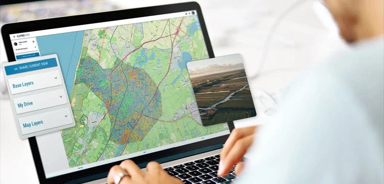
- Our software converts geospatial data into live maps in under 10 minutes. It can consume data of various types and formats and convert it into a cohesive end product. They can be shared with customers with only a simple web URL and an internet connection.
- Customers don’t need to download the maps to view and edit. It can all be done within the realms of the cloud itself, instantaneously.
- Our solution offers version control so always be up to date with suggestions, feedbacks and versions. Tracking has never been easier.
- Our solution offers multiple endpoints with access via API, Python, OGC protocols and web viewer. Stay ahead of your competition by offering your clients a plethora of data ingestion options
- Let’s talk money! We have a cost efficient subscription model which means that you only pay for the amount of data that you host on the server. Pay for what you upload!
The best part about all this is that the customer is up-to-date all the time on the project by having viewing-access. Once the project is completed, data transfer to the client is instantaneous and flexible. Enjoy the best project management experience with Ellipsis Drive. We are confident that this will in turn lead to sustainable growth in your business venture! Still want to know more about us? Get in touch with us and help us help you!
Liked what you read?

Subscribe to our monthly newsletter to receive the latest blogs, news and updates.
Take the Ellipsis Drive tour
in less than 2 minutes'
- A step-by-step guide on how to activate your geospatial data
- Become familiar with our user-friendly interface & design
- View your data integration options

Related Articles

Why AI is Reshaping Spatial Data Infrastructure
Artificial Intelligence is rapidly reshaping expectations around geospatial workflows. Organizations no longer want static outputs or slow analytics cycles. They want near real-time insights, scalabl
5 min read

Navigating the Cloud Spectrum: From Generalist to Specialized, and the Perfect Middle Ground
The modern cloud ecosystem spans a wide spectrum of offerings, from general-purpose infrastructure to highly specialized platforms built for domain-specific tasks. At one end, generalist clouds provi
5 min read

Unlocking the Potential of Data: Comparing Tabular and Non-Tabular Protocols
The world of data is a complex landscape and each year, the complexity of that landscape grows exponentially. A combination of new data capturing technology, data processing technology and demands fo
6 min read