Company Update
Introducing Ellipsis Map Engine: The First Raster Data Lakehouse for Scalable Spatial Data Science
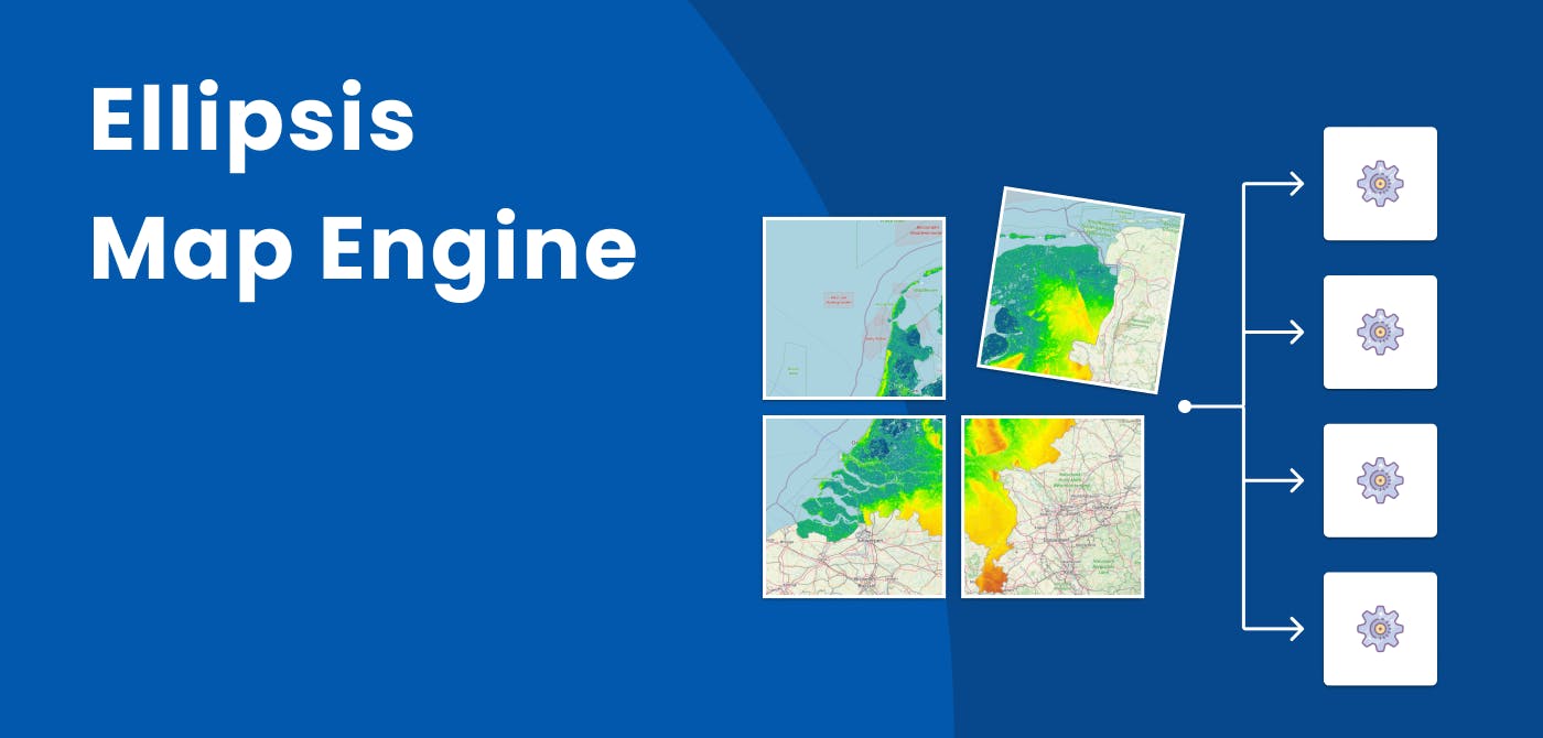
Ellipsis Drive (ED) is delighted to announce the launch of Ellipsis Map Engine, a map-native engine that revolutionizes spatial data science within the table-engine dominated data science landscape.
Countless discussions with industry-leading enterprises in EO, P&C and Ag Insurance and Engineering have highlighted major pains of data scientists in manual data preparation and integration. The market reveals the urgent need for a map-native compute engine specifically designed to manage non-tabular datasets like satellite, drone and DEM data. Ellipsis Map Engine was built to be that missing piece and fill this industry technology gap on scalable raster data storage, processing and compute.
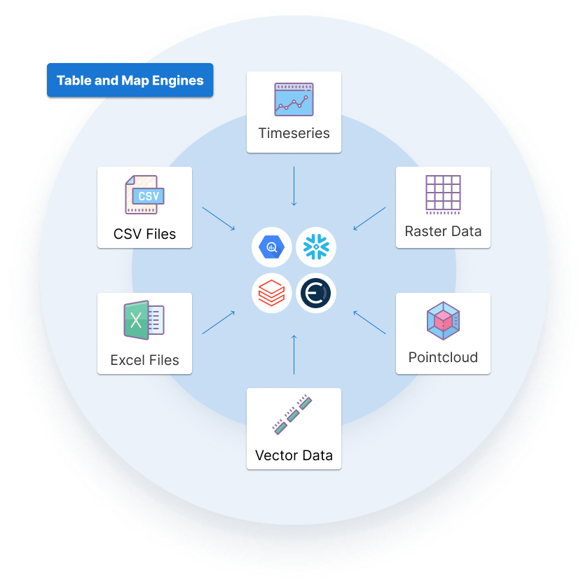
Ellipsis Map Engine is a map-native data lakehouse and distributed compute engine that is natively compatible with any type of geographic data including raster data. It allows users to run their spatial data analytics workflows instantly, without any manual work. Map Engine supports both map-reduce operations and layer-to-layer mappings, running these processes in a massively parallel way for lightning-fast results. Data professionals can offload many of the more complex tasks to the server-side, freeing them from the burden of implementing them manually. This results in faster analytics cycles and far more efficient use of resources.
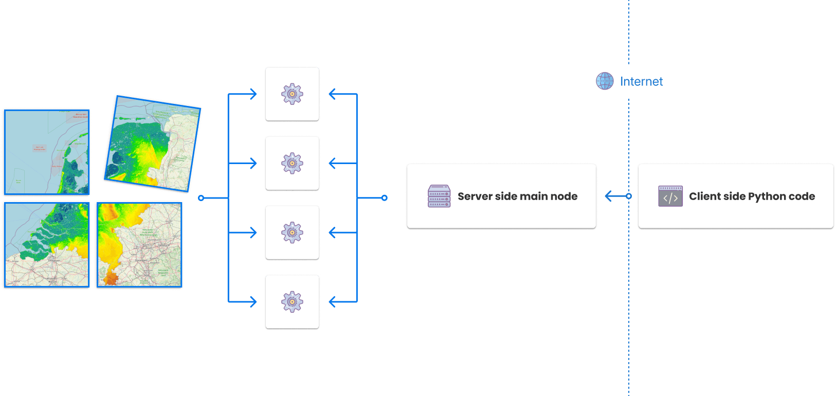
Ellipsis Map Engine complements and seamlessly interfaces with existing table engines like Databricks, Snowflake, Redshift and BigQuery to unlock the power of automated, high-performance, distributed analytics for raster data, vector data as well as other tabular data.
"For data professionals the act of conducting spatial Data Science at scale and publishing results for downstream use still requires a lot of manual steps and custom workarounds. This is a huge burden.”said Rosalie van der Maas, CEO & Co-Founder.“With Map Engine we are finally bringing a map-native engine to market that helps data professionals streamline and scale their spatial data operations."
Business gains with Ellipsis Map Engine
Getting instant answers as opposed to a 2-6 week delay due to single threaded analysis or the need to build ad hoc infrastructure to support more distributed analysis.
-> This unlocks new value for Data Scientists, Actuaries, and Geo Engineers working with EO and EO-derived raster data, empowering them to run complex and constantly evolving analytics workflows in a time-efficient and highly scalable manner.
Getting geographic nearness- and correlation-aware analytics for much more accurate risk assessments for physical assets.
-> For Data Scientists, consultants, and actuaries in the P&C and Ag (re)insurance sectors, this translates directly into better pricing models, more accurate (aggregate) risk maps, improved portfolio management, and smoother claims processes—all of which rely on EO data and require flexible spatial analytics.
-> For Data Scientists, consultants, and (geo)engineers in civil engineering, it means significantly faster and more precise answers to client’s questions—benefitting government agencies, environmental authorities, as well as energy and utility providers.
Automatic and instantaneous visualization and web servicing of inputs and results for immediate usability, integration and insight into spatial relationships and risk factors.
-> This is highly relevant for professionals charged with feeding insights into operational systems, typically relevant for claims management, portfolio management, maintenance dashboarding and risk mapping for decision makers.
-> For data/analytics creators, Ellipsis Map Engine adds value by ensuring analysis results are seamlessly accessible via any preferred endpoint. This ensures geospatial insights can be automatically integrated and updated into all client GIS & non-GIS systems simultaneously - streamlining last-mile data delivery and integration.
"With EO data gaining a more prominent role throughout geospatial analysis, the market has been calling for a truly scalable raster data framework. Ellipsis Map Engine's analytics capabilities opens up new use cases and applications for our enterprise customers in P&C Insurance, Agriculture and Energy relying predominantly on multi-source EO data for their critical operations.” said Rens Wijnia, COO.
With the launch of Ellipsis Map Engine, Ellipsis Drive is proud to fill a critical gap in the spatial data ecosystem—empowering users with a faster, smarter, and more scalable way to work with raster data. By combining the flexibility of a lakehouse with the power of distributed computing, Ellipsis Drive is enabling a new era of spatial data science that’s as seamless as it is powerful.
Read more about Ellipsis Map Engine.
Liked what you read?

Subscribe to our monthly newsletter to receive the latest blogs, news and updates.
Take the Ellipsis Drive tour
in less than 2 minutes'
- A step-by-step guide on how to activate your geospatial data
- Become familiar with our user-friendly interface & design
- View your data integration options

Related Articles
Ellipsis Drive Achieves Sustainability Partner Designation in the Google Cloud Partner Advantage Program
Amsterdam, The Netherlands, 27th Feb, 2025— Ellipsis Drive today announced that it has achieved the Google Cloud Ready - Sustainability designation in the Google Cloud Partner Advantage Program. By ea
4 min read

Answr and Ellipsis Drive Empower Businesses to Build Resilience Against Climate Risks
Cloudeo and Ellipsis Drive are proud to announce the integration of answr, Cloudeo's advanced climatic risk forecasting and analytics platform, with Ellipsis Drive, the cloud-based storage and file-s
3 min read

Tilebox and Ellipsis Drive partner to enhance the data chain of the Earth Observation Industry
We are delighted to announce that Ellipsis Drive will be partnering with Tilebox to enhance the full data chain of the Earth Observation (EO) industry, from satellite capture to end user delivery. Th
4 min read