Use Case
Earth Observation
Connecting Earth Observation Datasets to End Users Ft. NomadIQ
Contents
Introduction
“From established basic research and government land management to growing demand in carbon markets, hazard insurance, and even recreational apps, there's a rapidly developing market for satellite-based environmental datasets. The demand is still small relative to its fundamental value to society, so the market is subject to what we call in ecology "small-population stochasticity". That is, although each university lab, nonprofit, and company is competing for their unique position, disturbances to the system as a whole risk its viability for everyone. At this stage of the industry, growth and diversification are good for everyone, so the success of my company is positively correlated to the success of our peers and even our competitors. We as a collective, need to lower the barrier to data discovery.” said Joe Sexton, the Co-Founder and Chief Scientist of terraPulse, Inc and the Co-Founder/President of NomadIQ.
In the latest of episode of The Ellipsis Drive Podcast, our CEO Rosalie van der Maas and Joe Sexton engaged in an exciting conversation that revolved around the aforementioned remark— how the barriers for data accessibility and discoverability can be lowered, and the consequences of doing (or not doing) so.
The discussion was built around Joe’s own experience with terraPulse, Inc., a pioneer of satellite mapping and monitoring for large-scale sustainability, and NomadIQ, which is making those same datasets available on mobile devices for everyone. This article condenses the key insights from the podcast. You can watch the full episode here.
Let’s go!
Connecting Earth Observation Datasets to the End Users
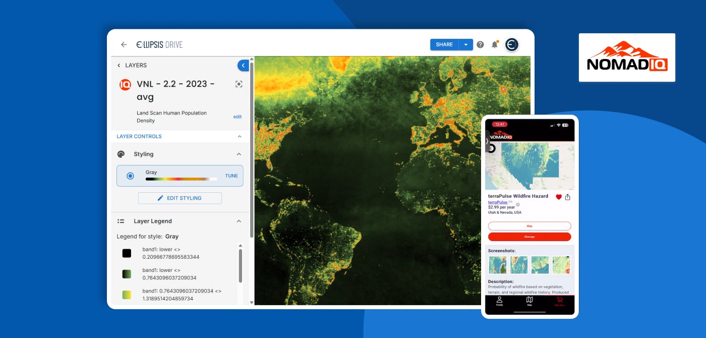
terraPulse, Inc. is a geospatial intelligence company that specializes in monitoring and mapping large-scale landscapes using satellite imagery. In collaboration with top data scientists, they create some of the best environmental datasets (forest, biomass, biodiversity, water, fire risks), enabling end users to make informed decisions. The terraPulse team made their name by creating the world’s first Landsat-based global tree cover dataset for NASA, and now they provide dozens of land-cover variables and indices via Application Programming Interface (API).
However, this is not the only tricky part of the puzzle. Making this rich data accessible to end users is still a major issue. Afterall, we’re dealing with complex spatial data files. “The biggest problem we’re dealing with right now is not a technical one,” said Joe, “it’s societal–data discoverability.”
That’s where NomadIQ enters the fray. NomadIQ is a mobile application that acts as a bridge to put spatial data into the hands of the end users via the mobile devices already in their hands. It can be viewed as an intuitive mapping application, with open source layers like Google Maps as the baseline that are then overlaid with insightful data layers such as global elevation, tree cover, water cover etc. You can find a quick demonstration of NomadIQ here.
Benefits of NomadIQ
There are 2 key capabilities that NomadIQ enables
- 24x7 access to spatial data: With NomadIQ, data scientists can have their data with them at all times. A picture speaks louder than a thousand words, and having geospatial intelligence visualized on mobile devices can help people overcome a lot of communication barriers. And of course, having data at hand also aids in on-ground validation. “If I see an unusual gap in the tree canopy cover in an area,” Joe said “I want to check it.”
- Data Collaboration: “Science works as a network,” Joe said. “Information gets better and sharper the more it is used and shared. It’s about creating throughput, and getting more nodes attached to the network.” Collaborating with other data scientists and stakeholders at conferences is imperative, especially when the industry is at such a critical juncture.
In a nutshell, NomadIQ lets data scientists tighten the feedback loop between our data and reality.
The Importance of Data Visualization
"In the beginning, I had to explain that maps are numbers, and you can do math on maps." said Joe. While a technical audience might agree with that in a heartbeat, the general public–the people we need to educate–might find it hard to wrap their heads around this concept. We can’t blame them. You believe what you see, which is why data visualization is so important.
Among scientists, information is still shared predominantly via journal articles–mostly text augmented by tables and figures. Adoption of the PDF and sharing over the web immeasurably increased the liquidity of scientific knowledge. Now data–and especially spatial data–are poised to increase that information liquidity again with cloud-native formats and protocols for the data themselves. But for spatial data, which has the advantage of visual intuition, a text based validation makes little sense. That’s where spatial data workflows run into a brick wall, and that’s where NomadIQ acts as a bulldozer. The audience to whom science can be explained, and by whom it can be validated, is increased from thousands to millions–or even billions when it can be viewed on a map. Think of it in terms of information compression: panning, zooming and querying a map is a far more intuitive and efficient means of communication than reading even hundreds of pages describing that same map.
“Data visualization is the more liquid form of scientific publication,” said Joe. “It’s more relatable to many more people. If we, as scientists, find a way to empower the general public through more involvement, then the general public will increase the value of science. That’s how we drive evolution and growth.”
Conclusion
As the geospatial intelligence landscape evolves, the challenge is no longer just about generating accurate environmental datasets, it’s about ensuring they reach the right hands in the most accessible and intuitive way. Through tools like NomadIQ, pioneers like Joe Sexton and organizations like terraPulse are addressing the crucial gap between data creation and data utilization. Their mission to lower the barrier for data discoverability is not only a technical endeavor but a societal one, grounded in collaboration, visualization, and real-world engagement. The future of Earth Observation hinges on making these datasets not just available, but actionable—and in that future, apps like NomadIQ may well be the new standard..
A big thank you to Joe Sexton for sharing his time, insights, and experience with us. His passion for making environmental data more accessible and impactful is both inspiring and timely, and we’re grateful for the opportunity to dive into these important conversations with him.
Check out the full podcast below:
Liked what you read?

Subscribe to our monthly newsletter to receive the latest blogs, news and updates.
Take the Ellipsis Drive tour
in less than 2 minutes'
- A step-by-step guide on how to activate your geospatial data
- Become familiar with our user-friendly interface & design
- View your data integration options

Related Articles

Infrastructure for a Multi-Cloud Environment
In our previous pieces on data location and sovereignty in Earth Observation (EO) ecosystems, we explored a question that has always existed, but has grown in priority: where is your geospatial data
5 min read
Building a Sovereign Earth Observation Infrastructure in Europe
In recent years, Europe’s conversation around data sovereignty has evolved. The point of discussion is not just about where information is hosted, but rather about which jurisdictions govern the enti
5 min read
A Stable Infrastructure for Radar derived 3D Data Visualization
In the latest episode of The Ellipsis Drive Podcast, our CEO Rosalie van der Maas hosted jC Clark, a professional with over 20 years of experience in Insurance and Earth Observation (EO) entrepreneur
7 min read