Disaster Management
Flood Risk Management with Ellipsis Map Engine
Contents
Floods Are Inevitable — But Their Impact Doesn’t Have to Be
Flooding is the most common and costliest natural disaster worldwide. In 2023 alone, global insured losses from natural catastrophes topped $123 billion, with floods accounting for a growing share of that total. As extreme weather events become more frequent and severe, flood-related damage is rising in both high-risk and previously unaffected areas.
For communities, the stakes are existential: lives lost, homes destroyed, livelihoods disrupted. For the insurance industry, the increasing volatility has created a risk modeling challenge with billions on the line. In fact, according to Swiss Re, the global protection gap for floods i.e. losses not covered by insurance remains alarmingly high, especially in low- and middle-income regions.
Whether it's record rainfall inundating cities, river systems breaching their banks, or coastal surges overwhelming defenses, the story is the same: floods are striking faster, hitting harder, and becoming harder to predict.
Managing this growing threat starts with understanding it, not just after the fact, but as it unfolds.
The Status Quo: Fragmented, Slow, and Hard to Scale
Despite the growing urgency around flood preparedness, the tools and workflows used to model flood risk remain surprisingly outdated. Most organizations rely on a patchwork of GIS software, static models, and siloed data. These processes are often manual, slow, and difficult to scale across large geographies or fast-moving scenarios.
Flood modeling typically starts with digital elevation models (DEMs), hydrological maps, rainfall forecasts, and other raster datasets. But ingesting and preparing these layers can be a labor-intensive process. Analysts often spend more time cleaning, clipping, and converting data than running actual simulations.
Once prepared, these datasets are processed using a mix of proprietary tools and custom scripts. They’re often built for one-time use or limited geographic scopes. Running the same analysis at scale, or adapting to new inputs (e.g. updated rainfall forecasts), can mean starting over from scratch.
What’s more, these workflows are not built for speed. In flood response, where every hour matters, traditional methods struggle to deliver insights in real-time. That lag can mean the difference between proactive action and reactive recovery.
Add to that the challenge of delivering results: outputs are often locked away in static maps or complex file formats, limiting accessibility to non-GIS users and decision-makers.
In short, today’s flood modeling status quo is:
- Data-heavy, but insight-light
- Slow to adapt to new information
- Disconnected from the people who need it most
The cost of that inefficiency is measured not just in time and money, but in lives and livelihoods.
A Smarter Approach to Flood Risk Analytics
Today��’s challenges demand a new kind of geospatial engine. The one that matches the speed, scale, and complexity of real-world disasters.
Ellipsis Map Engine is built to do exactly that. It combines fast, automated data ingestion with map-native analytics. It turns massive raster datasets into live, interactive insights that anyone can act on, whether they're a GIS expert or not.
Let’s take a flood risk scenario to illustrate how this works in practice:
A national disaster agency receives an updated rainfall forecast for a major river basin. The region includes vulnerable communities, critical infrastructure, and flood-prone terrain. With just 48 hours before peak rainfall, they need to know:
Where is the water likely to accumulate, and who’s in harm’s way?
Using Ellipsis Map Engine, the agency:
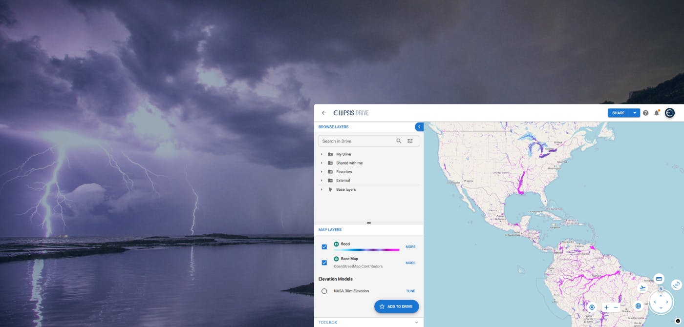
- Streams in fresh forecast data, combining it with digital elevation models (DEMs), soil moisture indices, and river basin maps already hosted in their environment.
- Performs spatial calculations instantly, identifying low-lying areas, likely accumulation zones, and flood extents. No manual prep or geospatial engineering required.
- Visualizes the outputs as live web maps, showing flood risk zones, population exposure, and infrastructure impact. All fully shareable and continuously updating as new data becomes available.
What once took days can now be done in minutes, giving emergency planners and response teams the lead time they need to act with confidence. And because these insights are served as interactive maps (and not static files), they’re accessible to everyone involved in the response effort, from technical analysts to policymakers and field coordinators.
For a technical deep dive you can read our CTO Daniel van der Maas’ Medium article that walks through how Map Engine processes raster data programmatically, thus, making these kinds of dynamic, large-scale spatial analyses possible.
Unlocking Business and Operational Value
Flood risk is a business challenge, a planning headache, and a matter of public safety. Next generation spatial data management can help organizations respond with speed and clarity where it matters most.
- Insurers gain faster, more accurate exposure assessments. Thus improving underwriting, pricing, and claims readiness.
- Governments and municipalities get real-time flood maps to guide emergency response, infrastructure planning, and zoning decisions.
- Infrastructure operators can model potential service disruptions and plan mitigation strategies before the water arrives.
- Emergency response teams benefit from live, visual risk layers that support faster, better-coordinated field operations.
When spatial intelligence is delivered in real time and in a language everyone understands, action becomes easier and outcomes get better.
Final Thoughts
As flood risks grow in scale and complexity, so must our ability to understand and manage them. Ellipsis Map Engine brings a step-change in how organizations engage with geospatial data. It makes it faster, easier, and more impactful to turn raw layers into live intelligence. Whether the goal is to protect people, assets, or infrastructure, the path forward starts with smarter maps.
Liked what you read?

Subscribe to our monthly newsletter to receive the latest blogs, news and updates.
Take the Ellipsis Drive tour
in less than 2 minutes'
- A step-by-step guide on how to activate your geospatial data
- Become familiar with our user-friendly interface & design
- View your data integration options

Related Articles
Near Real-Time Natural Catastrophe Assessment
Natural catastrophes such as earthquakes, floods, and forest fires are becoming more frequent and less predictable, largely due to the accelerating effects of climate change. This escalating volatili
6 min read
Satellite Radar Data to Monitor Land Subsidence
The Earth continues to go through drastic changes in the 21st century. As the human population rises and the exploitation of natural resources rises along with it, the Earth continues to retaliate in
3 min read
Ellipsis Drive and Catastrophe Modelling
Mastering your spatial data is critical for managing your risk. In this article, we take a deep dive in how spatial data management layers into Catastrophe modelling and how Ellipsis Drive can help yo
5 min read