Insurance Analytics
Tackling Land Subsidence with Ellipsis Map Engine
Contents
Introduction
Pipeline infrastructure is central to the Oil & Gas industry, enabling the safe and efficient transport of resources across long distances. But this infrastructure faces constant threats from natural forces. One of the most persistent problems being land subsidence.
Subsidence is the gradual sinking of the Earth’s surface. While it may happen slowly, the impact can be severe, especially when the land shifts unevenly. This creates stress points that can deform or rupture pipelines, leading to costly disruptions and serious safety risks.
For pipeline operators, early detection of ground movement is essential. But monitoring long, narrow pipelines (often in remote or hard-to-access terrain) is a technical challenge.
In this blog, we’ll explore how land subsidence impacts pipeline safety, how remote sensing is used to detect it, and how Ellipsis Map Engine helps streamline the entire analysis pipeline for faster, more reliable decision-making.
Land Subsidence: The Silent Killer
Land subsidence may unfold gradually, but its effects on pipeline infrastructure can be sudden and severe. If an entire region sinks uniformly, pipelines can typically adapt. The danger lies in uneven or differential subsidence, where parts of the ground move at different rates. This introduces bending and stress along the pipeline’s length, which can lead to cracks, leaks, or even catastrophic failure.
Pipeline networks often cross thousands of kilometers of varied terrain. The subtle nature of land deformation combined with the sheer scale of pipeline infrastructure make this a non-trivial task. So understanding and tracking changes is vital. And without timely insights, minor terrain changes can escalate into major operational and environmental hazards.
Remote Sensing and InSAR in Pipeline Monitoring
Monitoring pipelines over vast, often inaccessible terrain calls for tools that go beyond ground inspections. That’s where remote sensing, and specifically, InSAR (Interferometric Synthetic Aperture Radar) comes in.
InSAR analyzes radar data from satellites to detect ground movement with millimeter-level precision. By comparing radar images taken at different times, it reveals subtle shifts in the Earth's surface, making it an ideal method for detecting land subsidence along pipelines.
Because satellites capture wide swaths of land frequently (often daily), it’s possible to keep a close eye on changes over time. This makes InSAR an invaluable tool for pipeline monitoring, offering both coverage and frequency that ground methods can’t match.
But while the data is rich, working with it isn’t simple.
The Analytical Bottleneck
InSAR offers precise and scalable monitoring. But turning that data into actionable insights isn’t always straightforward, especially for pipeline operators.
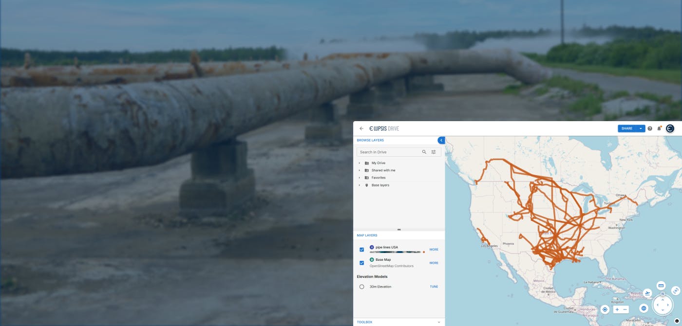
Pipelines introduce a unique analytical challenge. Unlike cities or fields, which are compact and neatly bounded, pipelines cut across vast, narrow, and irregular paths. Most geospatial tools are not built to efficiently handle such geometries. This mismatch leads to performance issues when processing large volumes of InSAR data focused on these thin corridors.
What’s more, InSAR data is refreshed frequently. Sometimes daily. Quick turnaround is critical. Delays in processing can mean delays in identifying deformation hotspots, leaving pipelines exposed to damage.
Despite having access to high-quality remote sensing data, many teams struggle to analyze it fast enough to act. The result is a growing bottleneck, one where slow tooling undermines the speed and scale of satellite monitoring.
Smoother Workflow with Ellipsis Map Engine
Ellipsis Map Engine is built to overcome the limitations traditional geospatial tools face, especially when it comes to complex, irregular areas like pipelines.
As a natively spatial compute engine, Ellipsis Map Engine is designed to handle oddly shaped regions with ease. By sharding these geometries into smaller, manageable chunks, it enables massively parallel processing of InSAR and other raster data streams.
By dramatically shortening the time it takes to analyze land subsidence, Ellipsis Map Engine empowers Oil & Gas operators to identify risks early and respond quickly. This reduces the chance of leaks, ruptures, and costly downtime.
Furthermore, Map Engine’s ability to scale means pipeline networks of any size or complexity can be monitored reliably.
In a sector where every delay can have cascading consequences, Ellipsis Map Engine’s blend of spatial intelligence and computing power offers a game-changing advantage.
The end result: faster insights, better decisions, and safer pipelines.
Conclusion
Land subsidence may be gradual, but its impact on pipeline safety is immediate and serious. As the Oil & Gas industry embraces remote sensing technologies like InSAR, the ability to rapidly analyze and act on complex spatial data becomes a critical competitive advantage.
/ rises to this challenge by providing the necessary infrastructure for fast, scalable, and precise land subsidence monitoring. Ready to see how Ellipsis Map Engine can transform your pipeline monitoring? Contact us today to learn more.
Liked what you read?

Subscribe to our monthly newsletter to receive the latest blogs, news and updates.
Take the Ellipsis Drive tour
in less than 2 minutes'
- A step-by-step guide on how to activate your geospatial data
- Become familiar with our user-friendly interface & design
- View your data integration options

Related Articles
Opportunities for the Insurance Industry (2023)
What is the difference between a challenge and an opportunity? It could be argued that they are one and the same. That a challenge is just an opportunity in disguise. In need of someone to innovate a
7 min read
How to Build a Spatial Data Catalog
Let’s start off with a hypothetical example. Say you are the manager of an Amazon warehouse and you receive an order to ship a book (maybe The Salt Path by Raynor Winn). But none of the million thing
5 min read
Automating the Ingestion of Spatial Risk Data into Data Warehouses
In today’s data driven world, insurance companies are always seeking out new ways to enhance their decision making process and gain a competitive advantage. With the increased rate of natural catastr
5 min read