Insurance Analytics
Advancing Climate Tech: The Imperative of Advanced Spatial Data Management
Contents
Introduction
As the world grapples with the urgent challenges of climate change, technology emerges as a critical tool in the fight against environmental degradation. Climate tech companies play a pivotal role in developing innovative solutions to address these issues. Amidst this context, the significance of advanced spatial data management becomes increasingly evident. This article explores the context, challenges, and opportunities surrounding advanced spatial data management within the realm of climate tech. But first, let’s set the context by defining what climate tech is.
What is Climate Tech?
Climate tech, short for climate technology or climate-focused technology, refers to a broad category of technologies and innovations that are designed to mitigate or adapt to the impacts of climate change. These technologies aim to reduce greenhouse gas emissions, enhance energy efficiency, and address various environmental challenges associated with global warming and climate disruptions.
Climate tech is a rapidly evolving field driven by the urgent need to address climate change. It involves a combination of scientific research, engineering, policy development, and entrepreneurship to create and implement innovative solutions that can help reduce the impacts of climate change and transition to a more sustainable and resilient future.
Despite the need being so urgent, it hasn’t been smooth sailing for climate tech companies and startups. The Climate tech industry is coming up against several challenges and obstacles that need to be addressed in order to maximize their impact.
The Challenge: Navigating Complex Climate Data
Climate data is a complex web of information, sourced from satellites, sensors, and various environmental monitoring tools. The sheer volume and diversity of this data present a significant challenge. Climate tech companies must decipher this data to derive actionable insights that drive effective strategies for climate mitigation and adaptation. Integrating and harmonizing data from these sources can be technically complex and time-consuming. Incompatibility issues can arise when trying to combine data from different sensors or models, hindering the development of integrated climate tech solutions.
What amplifies these issues is the absence of a robust spatial data management solution for navigating through the complexities of climate data analysis. Manual data ingestion, non-standardized formats, and disorganized repositories slow down the data processing pipeline. This delay hampers timely decision-making, undermines the accuracy of predictions, and hinders the ability to collaborate with stakeholders across sectors.
Challenges Faced Without Advanced Spatial Data Management
1. Delayed Insights: The manual nature of data ingestion and processing leads to delayed insights, hampering rapid response to emerging climate trends and events.
2. Data Inaccuracy: Unstructured data repositories increase the likelihood of errors and inaccuracies, undermining the reliability of climate analyses and forecasts.
3. Limited Collaboration: In an era where collaborative solutions are crucial, the absence of an advanced spatial data management solution hampers effective data sharing across organizations and sectors.
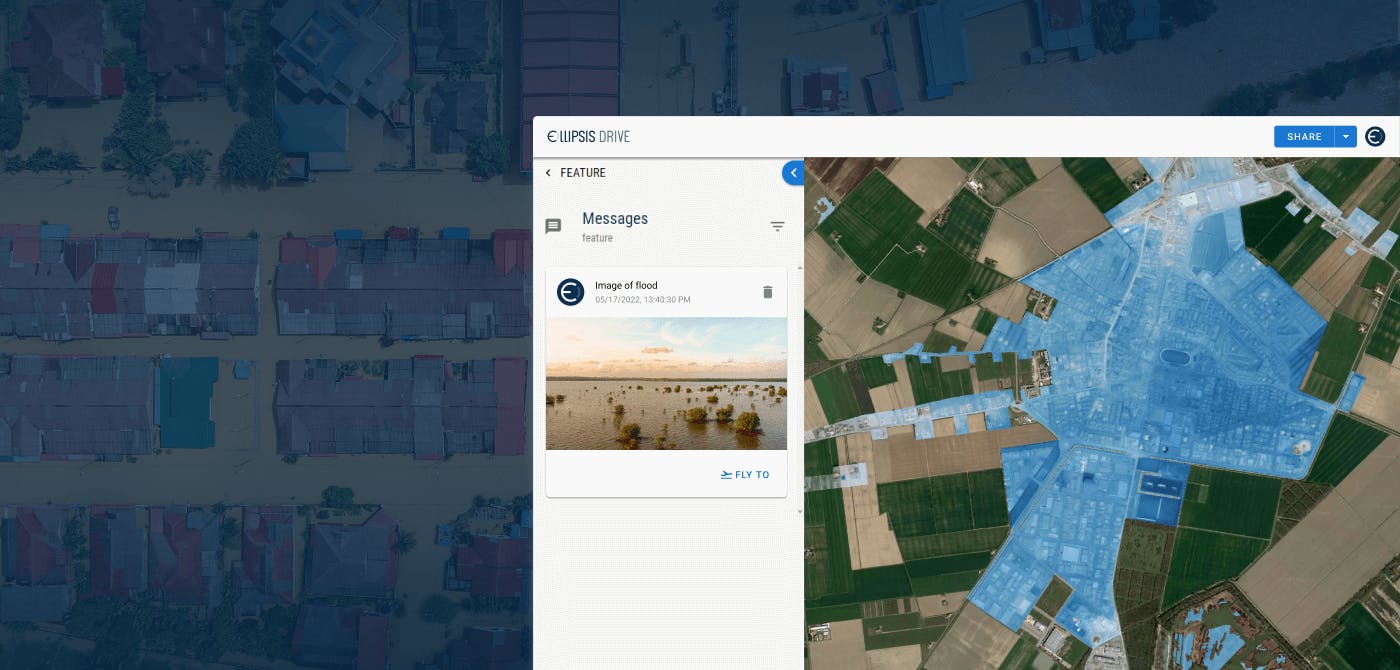
Use Case 1: Extreme Weather Prediction
Consider a climate tech company aiming to predict extreme weather events. An advanced spatial data management solution automates data integration from satellites, weather stations, and sensors. Structured and standardized data allows for the creation of accurate predictive models. This enables the timely issuance of alerts, empowering communities and authorities to take preventive measures in response to impending disasters.
Use Case 2: Precision Agriculture for Climate Resilience
In precision agriculture, advanced spatial data management is indispensable. It facilitates the integration of diverse data sources, such as satellite imagery, climate data, and soil information. This integrated data empowers farmers with insights into optimal planting times, irrigation schedules, and crop selection. The result is enhanced yields, resource efficiency, and climate resilience in agriculture.
Opportunities Offered by Advanced Spatial Data Management
1. Timely and Accurate Insights: Automated data processes ensure swift access to accurate insights, facilitating informed decision-making in response to changing climate conditions.
2. Innovation Catalyst: An advanced spatial data management solution frees up resources that can be dedicated to innovative climate solutions, driving the development of ground breaking approaches to climate change.
3. Enhanced Collaboration: Robust interoperability fosters collaboration across sectors, enabling climate tech companies to pool resources, share insights, and develop holistic solutions.
Conclusion: Pioneering Climate Innovation with Advanced Spatial Data Management
The imperative of advanced spatial data management for climate tech companies is undeniable. It transcends the challenges of data complexity, delays in insights, and limited collaboration. Through use cases like extreme weather prediction and precision agriculture, we witness the transformative potential of such solutions. By embracing advanced spatial data management, climate tech companies position themselves as innovators in the fight against climate change. The investment in this technology is not just a strategic move; it's a commitment to shaping a sustainable and resilient future for our planet.
Liked what you read?

Subscribe to our monthly newsletter to receive the latest blogs, news and updates.
Take the Ellipsis Drive tour
in less than 2 minutes'
- A step-by-step guide on how to activate your geospatial data
- Become familiar with our user-friendly interface & design
- View your data integration options

Related Articles
Tackling Land Subsidence with Ellipsis Map Engine
Pipeline infrastructure is central to the Oil & Gas industry, enabling the safe and efficient transport of resources across long distances. But this infrastructure faces constant threats from natural
5 min read
Opportunities for the Insurance Industry (2023)
What is the difference between a challenge and an opportunity? It could be argued that they are one and the same. That a challenge is just an opportunity in disguise. In need of someone to innovate a
7 min read
How to Build a Spatial Data Catalog
Let’s start off with a hypothetical example. Say you are the manager of an Amazon warehouse and you receive an order to ship a book (maybe The Salt Path by Raynor Winn). But none of the million thing
5 min read