Breaking Down Geospatial Data Silos Ft. Ellipsis Drive

Contents
The Technology Gap
Picture a scenario where the team members of a company working in various verticals, such as Sales, Marketing, Product, Finance and Customer Service, aren’t talking to each other. They all just go about their own business without any communication between them. No feedback is shared, no wisdom is imparted and no synergy is created. A lack of cohesion and low success rates are a natural consequence of working with such stark communication gaps.
This scenario is of course a simplification (condolences to those for whom it is not), but even in today’s day and age, there are companies where critical connections are missing. Walls are built not between personnel, but between the digital tools that different people are working with. So even while people may be freely communicating, the data and insights they rely on can not seamlessly flow from one individual or work unit to another. This is the data version of the Silo Mentality. This siloed nature of our data infrastructure acts as a ceiling to a company’s growth and prevents it from reaching its true potential.
Many proactive companies have figured out a way to break down silos for the non-spatial data by setting up data warehouses to facilitate searchability and more interoperable access across the enterprise. However, for geospatial data sets (data with a location component), companies are forced to live with the consequences of siloed spatial data because regular data warehouses do not support the proper structuring, indexation, queryability and interoperable rendering of this content. Here we identify; a key technology gap.
In this article, we are going to dive into the nagging problems around the siloed management and use of geospatial data. But more importantly, we are going to introduce you to the solution to this problem. Let’s go!
What are geospatial data silos? Skip this if you already know!
Geospatial data silos refer to isolated or segregated repositories of geospatial information within an organization or across different systems. These silos typically arise when data is collected, stored, and managed independently by different departments, teams, or applications, resulting in a lack of integration and interoperability.
The problems associated with geospatial data silos
The consequences of geospatial data silos are multifaceted. While the problems associated with this are endless, there are some crucial ones that are worth discussing here.
It is also important to note that most of these problems intertwine to create a complex web of challenges. They don’t exist in isolation. The upside to this is that they can all cease to exist simultaneously if the right actions are taken.
Data Redundancies - Siloed geospatial content equates to decentralized and non-synchronized workflows. This means that multiple copies of the same data exist in the organization and that versioning is immediately out of control. If someone wants to make sure they are using the latest version of any data, or the same version another colleague is using, this will be a constant struggle that technical teams get pulled into and waste their time on.
Opportunity Costs - Every minute that tech teams spend on ad hoc data wrangling is time they don’t spend on their core proposition: create insight, products and services. This narrows their window to come up with valuable, innovative and disruptive solutions.
Interoperability Issues - Silos often use different technologies, tools and standards, making it difficult to achieve interoperability. This impedes the integration and free flow of geospatial data and hinders easy collaboration and the adoption of unified solutions.
Data Security Issues - Security and access control mechanisms vary between geospatial data silos, potentially leading to inconsistent or inadequate data protection measures. This poses risk in terms of data security and compliance with regulations.
How Does Ellipsis Drive get rid of geospatial data silos?
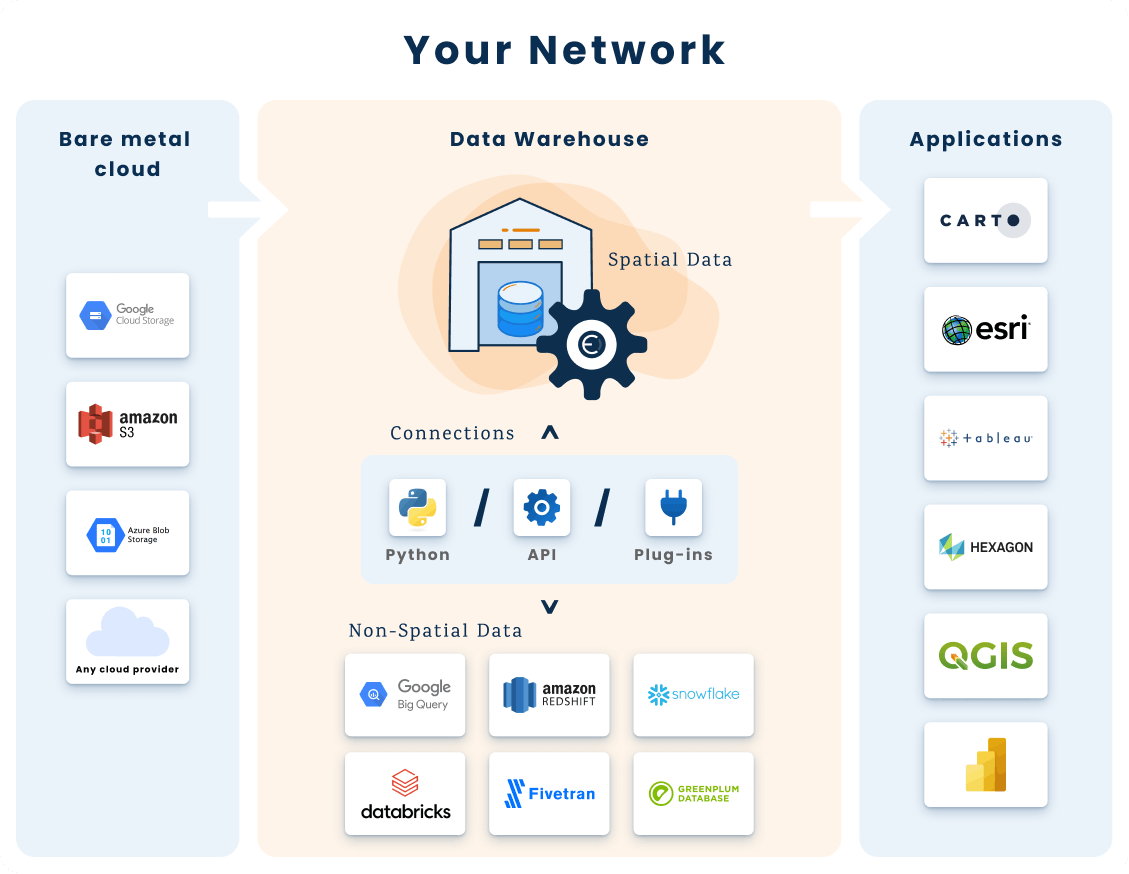
What solutions such as Snowflake, Databricks and Fivetran do for non-geospatial datasets, Ellipsis Drive (ED) does for geospatial datasets. ED is a fully interoperable, cloud-based, spatial data management solution that simplifies and automates spatial data transformation, management and integration. It breaks down geospatial data silos by ensuring access to spatial content from every workflow simultaneously, creating a homogenous data warehouse for stakeholders to work with.
ED can be launched on top of an existing data bucket, server or lake. Upon launch, all files get added to the existing ED index and ED starts acting as the bucket manager.
This converts all spatial data files (regardless of type, format and volume) into high performance web services that are available on a drag/drop or simple command line basis for high performance and interoperable use by analysts, data scientists, engineers and modelers via endpoints of their choice (such as Python, R, API, GIS software and Power BI).
The visual representation below encapsulates how ED fills the identifies technology gap -
What are the benefits of having a fully scalable spatial data infrastructure?
Upon launching a scalable, flexible and interoperable spatial data infrastructure, here’s what you will have that others don’t -
70% faster project completion for data scientists - Through automated data preparation and seamless API integration with Python and R packages, your data scientists can dive into analysis without delays.
15X faster onboarding for data vendors and partners - A streamlined onboarding process ensures a 15X reduction in technical implementation time, reducing the ingestion of larger spatial data loads from one month to just 2 days.
100X faster data querying- Patent pending tile tree archives and paged vector tiles ensure 100X faster data querying. This ensures high performance spatial data use for data scientists, modelers and developers.
Interoperability - You will unlock 600% faster spatial data transmission to other teams through full data interoperability.
To know more about getting the most out of your spatial data management solution, click here.
Conclusion
Organizations can now permanently break down their geospatial data silos and prevent future spatial data silos from occurring by deploying Ellipsis Drive on top of their existing data storage. This ensures that every single business unit, team and third party has fast and secure access to spatial data from all their workflows simultaneously!
Would you like to know more about how Ellipsis Drive can meet your business needs? Get in touch with our sales team today!
Liked what you read?

Subscribe to our monthly newsletter to receive the latest blogs, news and updates.
Take the Ellipsis Drive tour
in less than 2 minutes'
- A step-by-step guide on how to activate your geospatial data
- Become familiar with our user-friendly interface & design
- View your data integration options
