Use Case
JBA Consulting | The Pursuit of Resilience Against Climate Change
Contents
Introduction
In the late 2000s, the Environment Agency of England and Wales assigned an environmental engineering consultancy with an apparently impossible task - to create a flood map for the entire country in less than a year. Back in the day, computer models weren’t as advanced and fast as they are now. That provided the task at hand its impossibility quotient. But trendsetters and successful companies do not get deterred by such daunting challenges. Rather, they use it as a launch pad to create something innovative and long lasting.
The company came up with the world’s first grid based hydraulic model as a solution. That in turn, acted as a stepping stone for creating flood risk models using graphic cards of computers. This initial success came along with an important realization - they could use this method to map and model other countries too.
Fastforwarding to the present day, this company has become one of the leading environmental and engineering consultancies in the world, and has created a flood risk map for virtually every country in the world - JBA Consulting.
In a recent interview for The Ellipsis Drive Podcast, JBA Consulting’s Director, Dr. Mark Lawless was in conversation with our CEO, Rosalie van der Maas. In this article, we’re going to capture the essence of that interview and shed light on how JBA Consulting aims to create resilience against the changing climatic landscape. Let’s go!
What is a Resilient Society?
“I like to use the analogy of having many eggs in many baskets. For countries vulnerable to flooding and climate change led disasters, there is often no one solution that can provide them with the level of protection they need. So we address the problem with various different solutions simultaneously. The combined effect of these creates a resilient society in our books.”, said Dr. Lawless when asked about his rendition of resilience.
Traditional flood defense systems such as building concrete structures (dykes) still have a role to play in some places. But due to their overall negative impact on the environment, they can do more harm than good (not to mention the heavy price tag that comes along). As a response to this, JBA are leaders in a new ideology - combatting nature with nature.
Dr. Lawless further added, “We are more inclined now towards nature based solutions. For example, reforestation of the catchment area of the river. That’s going to slow the flow of water and give people more time to respond. Another example is the regeneration of mangrove forests. They act as a great barrier against storms and cyclones near the coasts. Aside from this, these types of options can also create jobs, improve biodiversity and trap carbon. Now that’s a resilient community! And of course, then you back these up with technology such as flood forecasting and early warning systems. As a company, we are also heavily investing in AI & machine learning. JBAi is one of our latest initiatives, which will help us further optimize our strategies and approaches.”
Stitching many integrated solutions together is what creates a truly resilient society. One that not only survives, but also thrives.
Spatial Data is Fundamental
To come up with the right set of solutions, one first needs to have a complete understanding of the hazard and risks that they are dealing with. Situational awareness becomes key. As a result, spatial data becomes key. Because how can one understand a location without location (spatial) data?
Dr. Lawless was quick to highlight the importance of spatial data in JBA’s operations, “Everything about a resilience project is spatial. Where people live, where the infrastructure is, where the opportunities for nature based solutions are, the hazard itself - spatial data is at the heart of it all. We still have to fill in a lot of gaps where data is sparse. But as time progresses, data becomes more easily available. We can combine on-ground observations with globally available data sets, for instance, to create a more complete virtual landscape of the situation.”
When creating a resilient community, there are lots of stakeholders involved – national and local governments and agencies, development banks like the World Bank and Asian Development Bank, infrastructure, utilities and transport authorities, community groups, local companies, Universities, international consultancies. Everyone involved in the project has a part to play and needs to be up to date on the ground situation for it to move forward smoothly.
It is crucial to ensure that this ground level understanding of the situation, insights and analysis translates into action on the field. For this to happen, a stable and flexible ecosystem/foundation needs to be in place for working with spatial data. This is where Ellipsis Drive comes into the picture!
Working with Spatial Data using Ellipsis Drive
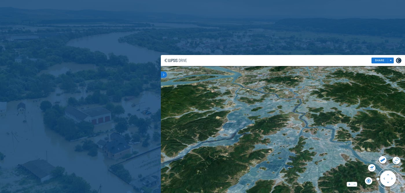
Ellipsis Drive is a fully interoperable, cloud-based, spatial data management solution that simplifies and automates spatial data transformation, management, and integration.
In the case of JBA, Ellipsis Drive provides fast and secure access to spatial content from any workflow by converting their uploaded geodata files into beautiful live maps and web services that can be accessed and queried via endpoints of their choice.
As a result of this transformation -
- Data layers can be visualized (in 2D & 3D mode) from a centralized location for faster and better decision making
- Every stakeholder (technical and non-technical) has easy access to complex spatial information through a user friendly interface
- Spatial data files within a project are versioned. Thus, multiple users in a project can simultaneously access spatial content without creating redundancies.
“Ellipsis Drive significantly enhances our ability to share spatial data with clients. A prime example of its efficacy is the ease with which we share our Global Flood Maps—a comprehensive dataset covering every location globally. The platform enables smooth access and collaboration, removing the need for direct involvement from our software development team. This not only frees up valuable time for our developers but also ensures our clients have effortless access to the data they need." - Dr. Mark Lawless, Director, JBA Consulting
Conclusion
2024 is an exciting year. Many of JBA’s projects in places like Burundi, Haiti, Ethiopia and Romania are entering a phase where years of conscious resilience effort will finally start bearing fruits. That’s just the starting point though. Slowly and steadily, the entire world is to follow.
Resilience against climate change is not something that can be achieved overnight. Nor is it something that is restricted to a specific location. Everything is connected to everything else on this Earth. It is only through our combined and collective effort that a resilient Earth can be created. Ellipsis Drive is delighted to play its humble role in helping JBA Consulting move a step closer towards creating a better and safer tomorrow.
Liked what you read?

Subscribe to our monthly newsletter to receive the latest blogs, news and updates.
Take the Ellipsis Drive tour
in less than 2 minutes'
- A step-by-step guide on how to activate your geospatial data
- Become familiar with our user-friendly interface & design
- View your data integration options

Related Articles

The Waterschapshuis: Drought Monitoring in The Netherlands
Despite the small size of the country, The Netherlands is the second largest exporter of agricultural products in the world. What’s their secret? What makes them tick? Well, it is a combination of ide
2 min read

Build Smart, Not Hard: How Element 84 Guides Clients with Spatial Data Infrastructure
For this episode of the Ellipsis Drive podcast, we sat down with Dan Pilone, CEO of Element 84, a geospatial engineering firm known for guiding organizations through some of their toughest technical
5 min read

EarthDefine: Protecting the Earth's Green Cover
Trees are the single most selfless beings on this planet. They have given so much to this world in so many ways. We literally owe them our lives by breathing in the precious oxygen that they produce.
3 min read