Use Case
The Deep4Sat43 Project - Monitoring Unhealthy Trees from Space
Contents
Introduction
Teamwork makes the dream work, a statement personified by the Deep4Sat43 project, a collaborative project which is proudly funded by Eureka Network.
The initiative is led by Spectro-AG and Ellipsis Drive along with several other key strategic partners (AgroInsider, BTech Analytics Technology, Cellari, Bewell Teknoloji Sanayi Ticaret A.S., Sarıçiçek Tarım Ürünleri San. ve Tic. A.Ş). Being an international and multi-organizational venture, the project involves a lot of moving parts and was in the making for over a year. It is safe to say that it will be worth the wait.
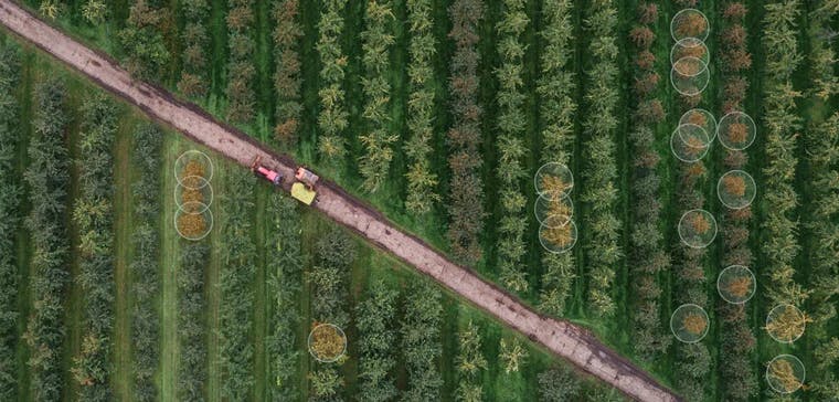
The primary goal of the project is to monitor unhealthy fruit and forest trees from space and use this information to nip the affected vegetation in the bud. With pressure increasing on the agriculture industry to feed the growing population, the project continues to grow in relevance and importance with each passing day.
Current Scenario
The saying ‘one dirty fish ruins the whole pond’ holds just as much truth for trees in an orchard. Early identification of contaminated crops is vital in preventing catastrophic damage.
Manual checks by ground personnel is no longer a viable solution. A manual check is devoid of consistency and is not a scalable solution. A smarter and futuristic approach is needed.
Precision Agriculture and Forestry is the need of the hour. This innovative approach provides accurate and timely assessment of the ground situation whilst being a big help in reducing the unavoidable overheads (financial and environmental).
The approach is also in line with the European objectives and targets of the Farm to Fork Strategy and The European Green Deal.
Spectro AG and the Deep4Sat technology
The centrepiece of the project is the Deep4Sat technology, an AI-driven deep learning algorithm that is ideated and designed by Spectro-AG. The technology has been fed with a database full of trees and the characteristics associated with it (size, soil type etc.). The algorithm also takes into consideration the legal requirements of the countries (Netherlands, Portugal, Turkey, and Denmark) where it is being deployed.
Using all of the above inputs, Deep4Sat will act as a backbone for a SaaS platform that will instantaneously convert satellite imagery into vector maps of unhealthy vegetation to raise an early warning for plant disease transmission and any other anomalies.
The UI/UX friendly platform would be accessible via API calls for B2C consumption (farmers/land operators) as well as B2B integration (technology companies). Spectro AG foresees the platform becoming a marketplace for organizations offering various AI powered analytical solutions on satellite imagery.
Ellipsis Drive’s Role
Being great advocates of the power of collaboration, Ellipsis Drive was extremely keen in being a part of this project. For creating an AI powered SaaS platform with quick and easy data exchange, Spectro-AG relies on Ellipsis Drive’s first-of-its-kind spatial data drive solution.
Our drive is designed for situations where proper exchange and collaboration on geospatial data is key. Easy data management and simultaneous access via all popular end points ensures that nothing gets in the way of fast results and seamless project management, as well as top notch data delivery and integration for users of Deep4Sat!
'Providing actionable geo-information about tree health that creates value for farmers and foresters is our core focus. It's great to work with Ellipsis Drive as a platform for data management, collaboration and integration to stay true to that focus while also providing end-to-end solutions for users and partners'
(Hamed Mehdipoor, Co-founder & Director, Spectro-AG)
Conclusion
Preventing a catastrophe is so much easier (and cheaper) than dealing with one. A proactive and modern approach is all it takes. The hardest part is the start, and with that out of the way, we see a green and clean future for the Deep4Sat43 project in 2022!
Liked what you read?

Subscribe to our monthly newsletter to receive the latest blogs, news and updates.
Take the Ellipsis Drive tour
in less than 2 minutes'
- A step-by-step guide on how to activate your geospatial data
- Become familiar with our user-friendly interface & design
- View your data integration options

Related Articles

The Waterschapshuis: Drought Monitoring in The Netherlands
Despite the small size of the country, The Netherlands is the second largest exporter of agricultural products in the world. What’s their secret? What makes them tick? Well, it is a combination of ide
2 min read

Build Smart, Not Hard: How Element 84 Guides Clients with Spatial Data Infrastructure
For this episode of the Ellipsis Drive podcast, we sat down with Dan Pilone, CEO of Element 84, a geospatial engineering firm known for guiding organizations through some of their toughest technical
5 min read

EarthDefine: Protecting the Earth's Green Cover
Trees are the single most selfless beings on this planet. They have given so much to this world in so many ways. We literally owe them our lives by breathing in the precious oxygen that they produce.
3 min read