Use Case
StraTopo: Mobility & Location Insights for a Smarter Society
As the world grows into one big globalized entity, location data continues to rise in importance and relevance with each passing day. People, goods and services are constantly moving from point A to point B. This has further increased the necessity of the science of routing and reachability.
In today’s article we bring our attention to a company that specializes in this field and has managed to successfully add value to organizations and societies.
Contents
StraTopo - Mobility & Location Insights for a Smarter Society
StraTopo is an organization based out of The Netherlands that specializes in delivering custom made geo-data and developing spatial solutions. They transform location data into valuable insights which are applied in city planning, real estate and policy making.
In essence, the company has mastered the concept of location intelligence and is leveraging that in the form of unique use cases.
Some of its key projects include -
- Data for Urban Logistics DeepHack
- Development of technology applied in the Bicycle Oriented Development concept Catchment area analyses around facilities like primary schools, bus stops, train stations, schools, etcetera.
- Experimental data study in the AI4Cities program focussed on the simulation of human mobility behaviour to predict and measure the effect of spatial changes on mobility
StraTopo's geospatial specialists have years of experience understanding their client’s goals and objectives. They combined their knowledge into customized web services offered via their live data platform.
StraTopo has a customer centric approach and its clients are continuously included during the entire delivery process via user friendly explanations, demo sessions and intermediate result sharing. This is where Ellipsis Drive comes into the picture.
Role of Ellipsis Drive
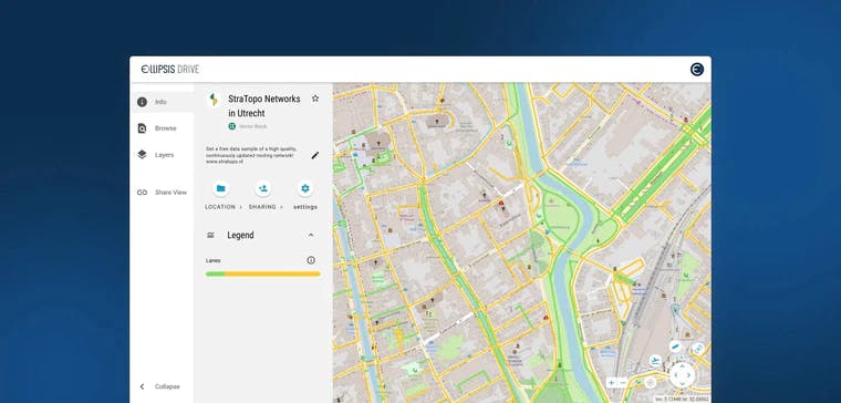
Ellipsis Drive’s unique geospatial drive solution provides Stratopo with the ideal tool to showcase the capabilities of their location-based models and pictorially depict and share their data. The ease of uploading and sharing geospatial data via Ellipsis Drive’s web viewer helps to speed up StraTopo’s operations.
Our web viewer is an excellent tool for easily sharing intermediate results and analysis with stakeholders of varied levels of technical expertise. The access control and folder organization capabilities further add value as StraTopo can neatly sort projects and give access to clients on a case-to-case basis.
Within a matter of clicks, Stratopo’s valuable data is converted into a real live map which can be easily collaborated on by participants simultaneously for better project management.
Conclusion
Location intelligence is becoming a key strategy piece for many organizations, in the Netherlands and globally. StraTopo continues to establish itself as an expert in this field and is quickly becoming a go-to entity for valuable network and location and reachability data across the Netherlands. We are happy to collaborate with StraTopo in their endeavour and bring them the attention that their valuable network data deserves.
Liked what you read?

Subscribe to our monthly newsletter to receive the latest blogs, news and updates.
Take the Ellipsis Drive tour
in less than 2 minutes'
- A step-by-step guide on how to activate your geospatial data
- Become familiar with our user-friendly interface & design
- View your data integration options

Related Articles

The Waterschapshuis: Drought Monitoring in The Netherlands
Despite the small size of the country, The Netherlands is the second largest exporter of agricultural products in the world. What’s their secret? What makes them tick? Well, it is a combination of ide
2 min read

Build Smart, Not Hard: How Element 84 Guides Clients with Spatial Data Infrastructure
For this episode of the Ellipsis Drive podcast, we sat down with Dan Pilone, CEO of Element 84, a geospatial engineering firm known for guiding organizations through some of their toughest technical
5 min read

EarthDefine: Protecting the Earth's Green Cover
Trees are the single most selfless beings on this planet. They have given so much to this world in so many ways. We literally owe them our lives by breathing in the precious oxygen that they produce.
3 min read