Use Case
Spatial Data-Powered Precision Agriculture Ft. VitiDron

Contents
Introduction
The world’s population is projected to reach 10 billion by 2050. That’s a lot of mouths to feed. This is occurring while climate change is on the rise, and natural resources are on the fall. Cracking the equation that can make this all work is not an overnight task. Rather, it demands a dynamic long term approach that focuses on efficient resource management and optimization.
On the latest episode of The Ellipsis Drive podcast, we had the opportunity to host Federico Enguix, Operations Director at Vitidron. Vitidron is a Spanish company specializing in precision agriculture using drone technology. As you can read below, Vitidron aims to be a part of the above mentioned equation that makes humanity's future more sustainable. In our talk, we zoomed in on their use case to understand the process of precision agriculture, and provided agriculture stakeholders with some fresh perspectives and workflows to chew on.
This article captures the essence of that conversation. Let’s go!
Vitidron: Spatial Data-Powered Precision Agriculture
Precision agriculture offers methods to increase crop yields without expanding farmland, and helps meet growing food demands sustainably. Spatial data powered technology is further transforming this practice at a crucial time.
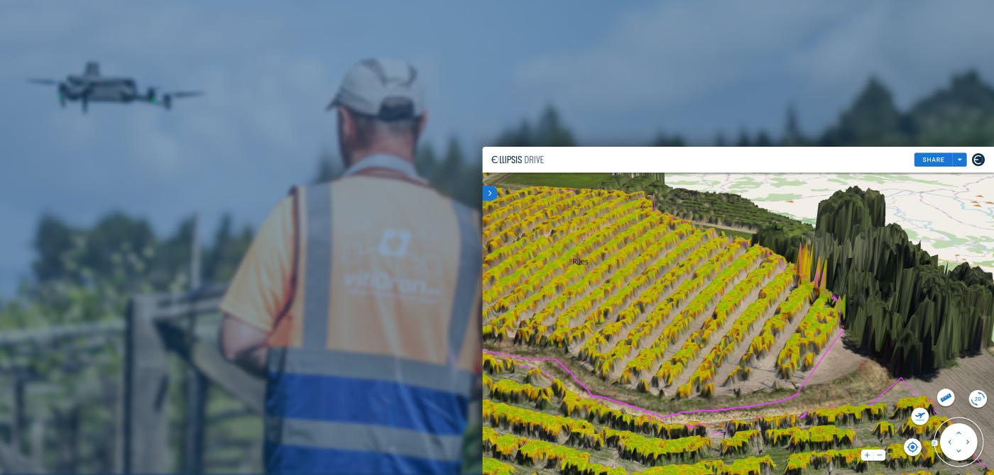
Vitidron provides services for vineyard management by using drones to capture high-resolution multispectral images to monitor crop health, water stress, and overall plant vigor. The multispectral images captured during terrain analysis are processed using advanced software and artificial intelligence to generate detailed reports. The various layers of the multispectral image — Normalized Difference Vegetation Index (NDVI) — indicates plant vitality, vigor and other stress markers invisible to the human eye.
These reports consist of historical data comparisons and real-time insights. Together, they aid in trend analysis. Crucial for long-term planning and adaptation to changing climate conditions. On a shorter time horizon, they help farmers make targeted decisions – enabling the use of irrigation, fertilizers, and pesticides only where and when they are needed, thus, reducing wastage and protecting ecosystems.
Managing a Spatial Data-powered Operation
Spatial data is at the heart of Vitidron’s workflow. Their Unmanned Aerial Vehicles (UAV) or drones capture a large amount of multispectral data that powers the rest of the workflow (that we briefly discussed in the above section). The multispectral data in and of itself is not the end product. It’s the input, which when processed turns into an insightful data product that helps farmers.
This part of the puzzle, the data transformation and dissemination, is where Vitidron sought help from Ellipsis Drive. Ellipsis Drive is a fully interoperable, cloud based, spatial data management solution. It automatically turns any spatial data that you have under management into a high performance and interoperable web service. This removes the need for all the additional ad hoc data wrangling work that is normally required from tech teams and provides a low threshold way to interact (i.e. search, render and visualize) with spatial data.
Here’s how Vitidron’s operations benefited from turning their spatial data into live web maps –
- Visualization - Ellipsis Drive’s simple and intuitive UI enables easy visualization of multispectral data sets for technical and non-technical users. Technical teams can directly jump into the analysis phase without getting bogged down by ad hoc data wrangling tasks.
- Customized Styling - Ellipsis Drive’s customizable styling options make visualization more intuitive for the end users and makes decision making easier.
- Access Management - Ellipsis Drive allows you to grant selective access to stakeholders depending upon their involvement in the project. This ensures data security and prevents data leaks.
- Versioning - Version control ensures stakeholders are up-to-date with all the changes. This reduces redundancies and adds efficiency to the workflow
- Real-time Collaboration - Ellipsis Drive turns spatial data files into high performance web services that can be shared with other stakeholders via a simple link. This takes away the need to download heavy files that served as a bottleneck in the past.
Conclusion
Vitidron’s operations exemplify how spatial data-powered technology is revolutionizing precision agriculture. By integrating drone-captured multispectral data with Ellipsis Drive’s real-time visualization, secure access management, and collaboration tools, Vitidron enables farmers to make informed, timely decisions. This synergy not only enhances operational efficiency but also supports sustainable practices, empowering farmers to optimize resources, reduce environmental impact, and plan for the future with confidence.
Would you be interested in trying out Ellipsis Drive to improve your business use case? Get in touch with our sales head today!
Liked what you read?

Subscribe to our monthly newsletter to receive the latest blogs, news and updates.
Take the Ellipsis Drive tour
in less than 2 minutes'
- A step-by-step guide on how to activate your geospatial data
- Become familiar with our user-friendly interface & design
- View your data integration options

Related Articles

The Waterschapshuis: Drought Monitoring in The Netherlands
Despite the small size of the country, The Netherlands is the second largest exporter of agricultural products in the world. What’s their secret? What makes them tick? Well, it is a combination of ide
2 min read

Build Smart, Not Hard: How Element 84 Guides Clients with Spatial Data Infrastructure
For this episode of the Ellipsis Drive podcast, we sat down with Dan Pilone, CEO of Element 84, a geospatial engineering firm known for guiding organizations through some of their toughest technical
5 min read

EarthDefine: Protecting the Earth's Green Cover
Trees are the single most selfless beings on this planet. They have given so much to this world in so many ways. We literally owe them our lives by breathing in the precious oxygen that they produce.
3 min read