Use Case
CAELI: Satellite-based Solutions for a Greener Future
Contents
Introduction
Let’s start this article with a not-so-fun fact. A recent study revealed that only 2 isolated methane leaks from fossil fuel fields in Turkmenistan were the cause of more global heating in 2022 than the entire carbon emission of the UK. To paint you a clearer picture, here’s another fact. The UK ranks in the top 20 countries in the world for carbon emission levels. This is very much in line with the pareto principle which states that 20% of the cause is responsible for 80% of the consequences.
Just think about it, had we been proactive in identifying these 2 methane leaks at a nascent stage, we could’ve avoided leaking 366m tonnes of carbon dioxide into the atmosphere. Isn’t the issue of climate change big enough to warrant our attention towards it? If we are to meet our agenda of keeping global heating below 1.5C, we can’t let go of such low hanging fruits. We have the technological advancements to globally map air quality and emissions from space. It is simply a question of intent and enforcement.
In this article, we shift our attention to CAELI, a Dutch company that has built the technology to tackle this important global issue of climate change and of the biggest contributors to it - air pollution. Their goal is to build a sustainable future and they use satellite-based solutions to drive towards this mission.
Keep reading to know all about their innovation and how Ellipsis Drive helps them in this mission.
CAELI: Satellite-based Solutions for a Greener Future
CAELI has built a smart and intuitive solution for globally mapping air quality from space. CAELI uses satellite data to detect and track emissions. The company’s advanced technology is able to accurately classify and analyse the concentration of the various gasses in the air. Some of the gasses that can be mapped and profiled are carbon dioxide, methane, nitrogen dioxide, ammonia and ozone. These are the prime contributors to air pollution. Profiling them is a critical step in taking proactive action towards curbing harmful emissions, the nitrogen crisis and the greenhouse effect.
A combination of several factors such as a 100 x 100 meter resolution, historic data from 2018 and world wide coverage ensures that there is no hiding from CAELI’s eyes in the sky.
But the real magic is in converting the raw data that comes down from the satellite into insightful dashboards that can be used by organizations, companies and government entities to make data driven decisions. CAELI utilizes advanced technologies for analyzing the raw data, extracting relevant trends and presenting it through user friendly visualization techniques.
Here is a brief on how the raw data is treated, processed and readied for further use -
- SRA algorithms for image sharpening
- Imputation algorithm to help “see through the clouds”
- Latest machine learning technology and AI algorithms to create meaningful dashboards and concentrations charts
With Environmental Social Governance (ESG) scores increasing in importance for all companies across the globe, CAELI’s solution offers a way for companies to achieve smart sustainability. Meaning sustainable and financially sound, both at the same time. Some of the key industries that utilize CAELI’s technology are Agriculture, Shipping, Energy and Health.
The next step is where Ellipsis Drive’s alliance with CAELI comes into the limelight. How does CAELI visualize this awesome piece of information that they are able to produce?
Coming up in the next section
How does Ellipsis Drive help CAELI?
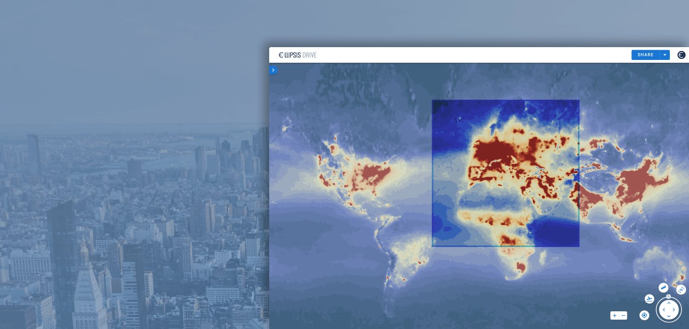
Let’s face it, what good is air quality data if it is not up to date? CAELI uses satellite data to provide real-time air quality data at your fingertips. CAELI grants global access to its users in order to stay up-to-date with the latest atmospheric conditions. How does CAELI operationalize this? CAELI’s satellite driven solution is hosted on Ellipsis Drive’s secure cloud. Ellipsis Drive converts CAELI’s solution into a live and interactive web map that can be easily managed through our web viewer by stakeholders of different technical abilities. Ellipsis Drive provides a stable platform for the consumption and management of CAELI’s satellite data driven sustainability solution.
An image speaks louder than words and numbers, especially when looking to capture environmental issues. Having visual proof, a dynamic and up-to-date map, is gold for stakeholders looking to understand and take action. As such, ED acts as a tool for hosting and visualizing CAELI’s air quality datasets on a live map that is easy to explore and consume for any audience. It also serves as a “proof-of-concept” for CAELI’s sales team by providing simple access for potential clientele and other relevant stakeholders. CAELI’s dashboard can be made accessible with a simple URL share.
Another key aspect where ED adds value is that of data delivery and integration. With the help of an API, Ellipsis Drive helps in integrating and delivering the analytical dashboards into end user’s applications and systems.
Final thoughts
Having a human brain is a super power. With great power comes great responsibility. It is our responsibility to leverage the technology available at our disposal for the betterment of our planet.
Would you like to know more about how Ellipsis Drive can improve your operations? Just book a free demo with our Head of Sales for a detailed walk through on how Ellipsis Drive can fit your business needs and help you master your risk. We are here to help!
Liked what you read?

Subscribe to our monthly newsletter to receive the latest blogs, news and updates.
Take the Ellipsis Drive tour
in less than 2 minutes'
- A step-by-step guide on how to activate your geospatial data
- Become familiar with our user-friendly interface & design
- View your data integration options

Related Articles

The Waterschapshuis: Drought Monitoring in The Netherlands
Despite the small size of the country, The Netherlands is the second largest exporter of agricultural products in the world. What’s their secret? What makes them tick? Well, it is a combination of ide
2 min read

Build Smart, Not Hard: How Element 84 Guides Clients with Spatial Data Infrastructure
For this episode of the Ellipsis Drive podcast, we sat down with Dan Pilone, CEO of Element 84, a geospatial engineering firm known for guiding organizations through some of their toughest technical
5 min read

EarthDefine: Protecting the Earth's Green Cover
Trees are the single most selfless beings on this planet. They have given so much to this world in so many ways. We literally owe them our lives by breathing in the precious oxygen that they produce.
3 min read