Use Case
Ordnance Survey's Geovation Connects Industry Challenges to Tech Start-Ups
Contents
Introduction
Geovation is a UK based organization that plays a crucial role in promoting and accelerating the growth of location, property and geospatial industry startups. It is an Ordnance Survey (the national mapping agency for Great Britain) initiative and together with HM Land Registry, Geovation offers an award-winning accelerator program that has proven to be the ideal platform for start-ups to scale and realize their true potential. Since conception, Geovation has helped over 150 geospatial and property start-ups that have collectively raised GBP 130 million.
Geovation’s accelerator programs provide cash funding up to GBP 20,000. But that’s just the tip of the iceberg. It’s hard to put a price tag on expertise, network, mentoring, visibility and countless other intangibles that are brought to the table.
Geovation's Accelerator Programs
Location data continues to grow in quantity and relevance. This has given birth to Location Intelligence and Situational Awareness where companies are using geodata to create insights that are forming the backbone of countless use cases and businesses for creating a better society.
The accelerator program run by Geovation has played a big part in bolstering this sentiment. Geovation runs a challenge whereby relevant geospatial companies are invited to solve real world problems.
Geovation provides all the necessary support and infrastructure (in the form of data, networking opportunities, research tools etc) to the brightest and best minds in the industry.
Here are some of the real world challenges that these bright minds solve -
Coastal Erosion Challenge
The challenge addresses the growing issue of coastal erosion that is affecting the UK (approximately 17% of the shores). Coastal erosion poses a threat to marine ecosystems, humans and businesses.
The challenge involves finding a sustainable solution to address the situation. Needless to say this, but geospatial data would play a big role finding a fitting solution. Geovation provides the participating start-ups with all the necessary resources and tools
Plastic Coastal Pollution Challenge
This challenge addresses the 12 million tonnes of plastic that is dumped into our oceans every year. The staggering amount of plastic ends up killing 100,000 marine life and needs to be dealt with urgently.
The challenge involved finding sustainable ways to alleviate the situation. Again, geodata is crucial in getting a complete picture of the problem at hand and creating solutions based on the geo-insights obtained. New technologies of remote sensing the oceans have been extremely helpful in this endeavour.
Some past winners of the challenge include GlobalTrust and SatSense Solutions that created impressive solutions to combat Coastal Pollution issues.
Geovation's Data Dissemination Dilemma
Geovation deals with an enormous amount of geodata which is disseminated to participating start ups for them to work on. The dissemination of these complicated geospatial datasets is easier said than done. Geovation encountered a major problem in providing easy access to the countless start-ups participating in the accelerator program.
Organizing and managing the data itself became the challenge as most of these companies’ time was spent on data wrangling. Creating analytical dashboards and insights requires a certain base-level of infrastructure. When the infrastructure is missing, data analysts will spend some 80% of their time on building this ad hoc, only to run into scaling and feature limitations later.
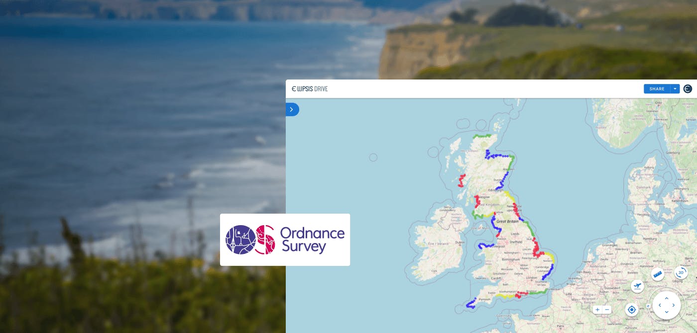
Ellipsis Drive for Spatial Data Management
As an organization that is focussed on results, Geovation realized that this issue needs to be addressed. This is where Geovation’s partnership with Ellipsis Drive (ED) comes in. ED acts as the ideal spatial data management tool. ED automatically transforms Geovation’s spatial data files into fully interoperable web services, which can be easily managed, accessed and used at high performance by any authorized audience via their own endpoints of choice. This means that no additional data transformation, re-projection, structuring, tiling or indexing is necessary.
Access control is also a major issue that Ellipsis Drive tackles. Ellipsis Drive gives project owners (Geovation in this case) the freedom to give customizable access as per the need or level. Thus, access doesn’t have to be general anymore, it can be differentiated and restricted as per geographies, roles and organizations.
The entire workflow has been optimized as a result of this partnership. Geovation’s spatial data files are now easy to manage and access via Ellipsis Drive’s web UI in addition to the endpoints, off-the-shelf GIS softwares and protocols that developers, data scientists and GIS experts prefer (such as Python, QGIS, Mapbox, Power BI, Leaflet, ArcGIS, OGC or via a direct API). GIS experts can now directly get to their real work - analyzing spatial data and deducing beautiful, actionable insights that tie into the use case.
Final Thoughts
Geovation is an important vehicle in the growth of the geospatial industry. It provides spotlight and guidance to Geotech start-ups at a crucial juncture in their lifecycle, thus allowing them to scale. Their initiatives help fast track the growth of these companies and realize their true potential.
We all agree that location data has the power to truly change the world by providing a whole new dimension to the problems at hand. And empowering companies that work with this data is the fastest and surest way to bring these changes to life.
Ellipsis Drive is indeed delighted to play a part in this vision and be the lens (quite literally) through which the new world is seen.
Liked what you read?

Subscribe to our monthly newsletter to receive the latest blogs, news and updates.
Take the Ellipsis Drive tour
in less than 2 minutes'
- A step-by-step guide on how to activate your geospatial data
- Become familiar with our user-friendly interface & design
- View your data integration options

Related Articles

The Waterschapshuis: Drought Monitoring in The Netherlands
Despite the small size of the country, The Netherlands is the second largest exporter of agricultural products in the world. What’s their secret? What makes them tick? Well, it is a combination of ide
2 min read

Build Smart, Not Hard: How Element 84 Guides Clients with Spatial Data Infrastructure
For this episode of the Ellipsis Drive podcast, we sat down with Dan Pilone, CEO of Element 84, a geospatial engineering firm known for guiding organizations through some of their toughest technical
5 min read

EarthDefine: Protecting the Earth's Green Cover
Trees are the single most selfless beings on this planet. They have given so much to this world in so many ways. We literally owe them our lives by breathing in the precious oxygen that they produce.
3 min read