Natural Resource Management using GIS Technology
Technology has long been an important management tool used to preserve natural resources. Many technologies have been developed over the years to suit various needs. In some cases, management practices have been perfected and adapted to suit specific environmental and resource issues.
Today, technology has also been used to develop remote sensing and Geographical Information System (GIS) tools that are now widely used to gather data essential for the effective management of natural resources. These tools provide a strong foundation for policy decisions related to environmental sustainability and growth.
To provide you with a clearer picture of how it all works, this article will discuss the application of GIS in natural resource management.
Here's what you need to know:
Contents
Application of GIS in Natural Resource Management
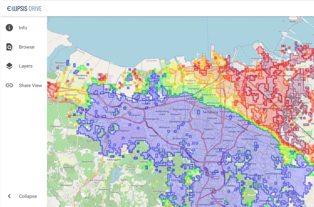
GIS enables information to be captured, stored, analysed, and presented in an easy to understand, simple to view, and cost-effective way. GIS is the science of taking data, converting it into geographical information, storing it, and visualizing it to be used to make informed decisions.
Hazard and Risk Assessment
GIS is used to identify and assess natural hazards effectively. It is also used to identify areas prone to disasters and other environmental risks. In the case of natural disasters, GIS is used to conduct risk assessments to determine the areas prone to experiencing severe weather and climate change.
It also generates maps that show the estimated extent of damage that may occur in the event of a disaster.
For example, GIS can accurately identify the areas that are prone to experiencing flash floods and landslides. By using GIS to conduct risk assessments, the government can identify the areas that need to be mitigated to reduce the impact of natural disasters and climate change.
Change Detection
Because GIS can capture, store, and visualize spatial data, it is ideal for monitoring changes in the environment that may affect natural resources.
GIS is used in change detection projects to monitor the impact of human activities on the environment. It is also used to identify areas that are vulnerable to these changes and may require special attention and protection.
Analysis and Modelling
GIS application in natural resource management also involves data analysis and modelling. GIS is used to generate maps and charts that will allow you to analyse geographical data. The maps and charts can model environmental trends, patterns, and conditions.
For example, GIS generates heat maps that provide detailed and accurate information about population distribution and density, land use, and settlement patterns.
The maps generated by GIS help government departments, public agencies, and agencies in charge of natural resource management to prepare, implement and monitor the management plans for specific regions.
Join the Community
Subscribe to our monthly newsletter to receive the latest blogs, news and updates
Environmental Monitoring
Environmental monitoring is also carried out by GIS technology. GIS monitors the growth and decline of natural resources and changes in land use, land cover, and land-use changes.
GIS has made it possible to monitor environmental conditions in real-time. It is used to produce maps that show ecological conditions, such as water bodies and pollution levels in rivers. For example, GIS is used to monitor the water bodies in the state to detect the potential dangers of water contamination that can affect health and the environment.
The Impact of GIS
The importance of resources today cannot be underestimated. GIS in natural resource management is a great way to protect our natural resources and ensure that they are available to the public. Many tools and technologies are available to help you manage your natural resources. These include GIS and aerial imagery, and mapping.
If you are interested in cloud GIS software, we can help you. Ellipsis Drive is optimized for sharing, collaborating on, and selling geospatial content. It empowers professionals to safely activate, manage, and share data in under ten minutes via the web. Contact us today to learn or get started online now.
What can Ellipsis Drive do for you?
Make spatial data management easy. Connect your data to your target audience in minutes.
Support all popular data endpoints and protocols off-the-shelf.