GIS
Change Detection using Remote Sensing Data & Temporal GIS Analysis
Contents
The Age of Information
Remote sensing analytics companies are highly sought after in the current marketplace. It comes as no surprise really. We are living in the information era and remote sensing analytics companies provide just that, valuable information!
Do take note that there is a huge difference between data and information. Data is raw, voluminous and oftentimes, useless. On the other hand, information is power. Information is insightful and helps in making well informed decisions that might just be the difference between success and failure.
Talking in terms of the geospatial industry, remote sensing analytics companies are the difference between data and information. Using powerful algorithms, they are able to convert large amounts of data into information that is used by organizations of all sizes and forms for their decision making.
Using Remote Sensing Data for Temporal Analysis
Today, many organizations use remotely sensed images for different use cases. One of the most common uses for such images is something called change detection or change analysis. As the name implies, change detection or analysis helps organizations detect changes using high-resolution images of different places.
Recently, such change detection activities have been paired with GIS for specific purposes. Today, we'll talk about how spatial and temporal GIS analysis is paired with change detection and how it benefits many activities.
How Change Detection using GIS Work?
GIS softwares combines spatial data with statistical data to deduce insightful information. The spatial data mentioned is remotely sensed and gathered by equipments such as drones, UAVs or satellites.
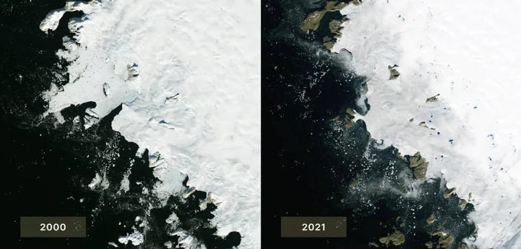
Now if the data is collected and analyzed over a period of time then that gives us a change detection dashboard to identify an aspect of a specific feature over time and is used in many ways, such as understanding forest coverage changes, ice sheets, changes, and the like.
It can detect an aspect of a specific feature in two different time periods. For example, when tracking retail stores, change detection can be used to identify any changes in the number of retail stores that popped up five years ago versus now.
Change detection can also be used to track a movement of a specific feature, the feature's shape and the feature's size.
Applications of Change Detection Software
By using a time series powered by visual data, stakeholders are able to create highly insightful predictive models and forecasts that help make smarter decisions. Here are some common applications -
Forest Fire Prevention - By merging data sets, forest fire specialists can make predictive analysis of the rate of wildfires and are even predicting fires by simply analyzing forest topography. This is being used to create fire prevention plans that are used by frontline emergency rescuers to prepare disaster mitigation strategies.
Deforestation Trends - Environmentalists are using change detection to identify areas that are highly prone to deforestation. One example that comes to mind is the work done by Project Canopy to protect the tropical forests of The Congo River Basin. Resources, financial and otherwise are being used efficiently by leveraging these change detection models.
Water Management - Natural water is a scarce resource and monitoring it is the first step towards preserving it. Water organizations are carefully monitoring any changes that are occurring in the water table to create conservation plans.
When considered at a point in time, the above issues are quite easy to slip under the radar and become underlying threats. But when compared and collated with past data sets, they can provide powerful insights that can be the difference between life and death.
Challenges for implementing Change Detection & Temporal GIS Analysis
Believe it or not, the hindrance to these remote sensing analytics companies is not the inadequacy of their algorithms anymore. It never was really. Their algorithms do a great job in deciphering data. The roadblock is turning out to be the distribution and integration of this valuable information with relevant stakeholders and their systems.
More and more organizations are wanting to get involved with geospatial data and remote sensing companies because of the value that it adds. Traditionally, data exchanges would occur via FTP transfer, WeTransfer or Google Drive. But these methods barely get the job done with their limited functionality. There is added pressure now to deliver information efficiently, flexibly and swiftly.
Some advanced remote sensing companies do partly solve these issues by offering an API and/or a custom web application that offer data scientists and other end-users flexible data delivery, but these end-to-end industry-tailored vertical integrations can hinder the core focus of an analytics company: creating valuable analytics and information products based on remotely sensed data.
USE CASE: Ilionx’s Automated Change Detection for optimized water management
Dutch tech company Ilionx supports water management authorities by automatically identifying physical changes in waterways such as streams, rivers, and canals. These insights help water authorities to make their operations safer and more effective.
However, in building such an automated change detection system, Ilionx has to face its own set of challenges. The remote sensing team at Ilionx that leads this effort has a client-in-the-loop development process. This is a very smart way to provide quality results and fitting solutions that truly delight users but it also leads to a cumbersome feedback phase.
Sharing intermediate results with clients can take a lot of time, and providing clients with an intuitive way to give feedback was not originally in place. As such, the process of getting clients up-to-date and in the loop to harvest valuable input felt confusing and very slow-moving at times.
Setting out to find a better way to work with clients constructively and painlessly, Ilionx decided to use Ellipsis Drive as a tool for live collaboration. Leveraging the ability to easily share and iterate on spatial data, Ilionx is now able to keep clients in the loop on the development of its solutions and can receive feedback without extra effort. Project versions, changes, and notes are all logged for collaborators to use.
“Ellipsis Drive provides a full solution for data sharing, management, and collaboration when relaying our results to clients”
Dominique Cirkel, Data Scientist & Remote Sensing Expert, Ilionx
With an off-the-shelf feedback flow in place that keeps clients up-to-date, the team can focus on creating unique insights of the highest quality for their clients. Empowered by Ilionx’ change detection service, water authorities can more easily respond to critical changes in waterways, reducing any potential for dangerous situations while saving taxpayers’ money.
Change Detection and GIS for Organizations
In summary, change detection and GIS can work together by providing various spatial, temporal, and even multi-spectral data to help users create proper analyses of a particular location. How it is used, of course, is highly dependent on the organization deploying change detection and GIS.
Regardless, change detection has provided the information that organizations need to make more sense out of the data, thus allowing them to make the right management decisions to adapt to the ongoing changes in various locations.
Ellipsis Drive offers a simple storage-based business model to give clients the chance to activate, manage, and share spatial data via the web quickly and efficiently. If you are looking for cloud GIS software to manage your spatial data effectively, work with us today!
Liked what you read?

Subscribe to our monthly newsletter to receive the latest blogs, news and updates.
Take the Ellipsis Drive tour
in less than 2 minutes'
- A step-by-step guide on how to activate your geospatial data
- Become familiar with our user-friendly interface & design
- View your data integration options

Related Articles

Why AI is Reshaping Spatial Data Infrastructure
Artificial Intelligence is rapidly reshaping expectations around geospatial workflows. Organizations no longer want static outputs or slow analytics cycles. They want near real-time insights, scalabl
5 min read

Navigating the Cloud Spectrum: From Generalist to Specialized, and the Perfect Middle Ground
The modern cloud ecosystem spans a wide spectrum of offerings, from general-purpose infrastructure to highly specialized platforms built for domain-specific tasks. At one end, generalist clouds provi
5 min read

Unlocking the Potential of Data: Comparing Tabular and Non-Tabular Protocols
The world of data is a complex landscape and each year, the complexity of that landscape grows exponentially. A combination of new data capturing technology, data processing technology and demands fo
6 min read