Use Case
California Data Collaborative: Smart Water Management Solutions
They say the next world war is likely to be because of the world’s water problems. Well, we really hope that it doesn’t come to that. But closing your eyes to a problem doesn’t mean that the problem doesn’t exist. Water scarcity is a problem with increasing significance.
California is one such state that has seen the worst of these water problems. The state has had several episodes of droughts which have only worsened as a result of climate change and uncertain precipitation.
But things have brightened up in recent years. With growing awareness of the situation, the citizens of California have come together to make small changes in day to day lives that have resulted in sizable changes in the State’s water situation.
Contents
California Data Collaborative
The cause is further helped by organizations such as California Data Collaborative (CaDC) that have made it their mission to tackle California’s complex water crisis. The organization is led by water managers with the intention of using data science, spatial imagery and analysis for making better decisions to conserve and monitor water resources in California.
Knowing when and where to invest can be the difference between success and failure. CaDC provides you a holistic picture of the situation. It creates custom analysis tools and visualizations that help stakeholders make informed decisions and implement policies.
Current Project: A long term framework to regulate water use efficiency
The state of California has come up with a long term initiative to ensure efficient usage of water resources. This involves each water supplier within the state having their own customized water objectives (tracking outdoor residential water usage to be more precise). This is monitored by measuring the amount of irrigated and irrigable landscape in an agency’s service area.
High resolution satellite imagery of the landscape is created by an external consultancy, which in turn is passed on to the water agencies in the state to assess their respective water situation. Unfortunately, the water agencies are not technically equipped to consume the spatial data shared with them.
Being voluminous and technical in nature, the spatial data files could not be viewed for a comparative study on an ordinary laptop that may lack RAM capacity and any pre-installed GIS software. Having every stakeholder interactively explore the data was simply out of the question. The whole operation was prone to data lags, miscommunication and project mismanagement as a result.
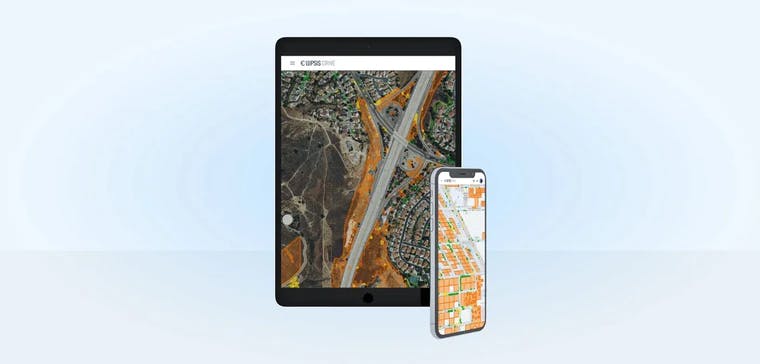
A simple and collaborative way to visualize high volume spatial data
CaDC decided to use Ellipsis Drive to smoothen things out. By hosting their spatial data on Ellipsis Drive’s cloud, it was converted into a live and interactive map that is easily accessed and explored by all water agencies. The Ellipsis Drive viewer is optimized for easy and high performance data visualization and exploration on any device.
Ellipsis Drive’s support system and simple storage based pricing model was also something that was greatly appreciated by CaDC.
''Ellipsis Drive offers superb customer support and transparent storage-based pricing. A valuable combo that is hard to find.''
- Chris Tull, California Data Collaborative
Conclusion
Having tasted the power of the cloud and easy collaboration on high volume data, CaDC is interested in expanding its partnership with Ellipsis Drive to other use cases as well. Particularly leveraging Ellipsis Drive’s API as a tile server for use in web applications.
As an organization we always strive to provide the best service to our customers. There is nothing more satisfying than a happy user. We are confident that California Data Collaborative will make its mark in the State’s (and the world’s) fight against the water crisis.
Liked what you read?

Subscribe to our monthly newsletter to receive the latest blogs, news and updates.
Take the Ellipsis Drive tour
in less than 2 minutes'
- A step-by-step guide on how to activate your geospatial data
- Become familiar with our user-friendly interface & design
- View your data integration options

Related Articles

The Waterschapshuis: Drought Monitoring in The Netherlands
Despite the small size of the country, The Netherlands is the second largest exporter of agricultural products in the world. What’s their secret? What makes them tick? Well, it is a combination of ide
2 min read

Build Smart, Not Hard: How Element 84 Guides Clients with Spatial Data Infrastructure
For this episode of the Ellipsis Drive podcast, we sat down with Dan Pilone, CEO of Element 84, a geospatial engineering firm known for guiding organizations through some of their toughest technical
5 min read

EarthDefine: Protecting the Earth's Green Cover
Trees are the single most selfless beings on this planet. They have given so much to this world in so many ways. We literally owe them our lives by breathing in the precious oxygen that they produce.
3 min read